

United States: Intense surplus to persist in W, SW states
29 June 2023
THE BIG PICTURE
The 12-month forecast ending in February indicates widespread surpluses throughout western and southwestern states to continue, with isolated deficits intensifying in the Pacific Northwest. Similarly intense anomalies are expected in various areas of the noncontiguous U.S.
Extreme to exceptional surpluses are expected to occur in the following areas:
Central to southern California, throughout much of the southern Sierra Nevada region, spreading west into coastal regions near the Salinas River. These surpluses spread across much of the state’s southwestern areas.
Nevada, widespread throughout much of the state’s central to northeastern regions. These anomalies continue in southern Idaho, in areas near the Snake River, and northwestern Utah, in most areas near the Great Salt Lake.
Northeastern Arizona, appearing in pockets, crossing the border into nearby regions of western Colorado and New Mexico.
Central Montana, east of the Helena-Lewis and Clark National Forest.
Alaska, widespread throughout the state’s western regions, as well as in southeastern areas near the Copper River.
Severe to extreme deficits are anticipated in several areas, including:
Washington and Oregon, in western regions of the Coast Ranges.
Central Idaho, in the Salmon River Mountains.
Southeast Louisiana, with exceptional deficits appearing in the Mississippi Delta.
Western Florida, near the St. Martins Marsh Aquatic Preserve.
The 3-month maps (below) show the evolving conditions in more detail.
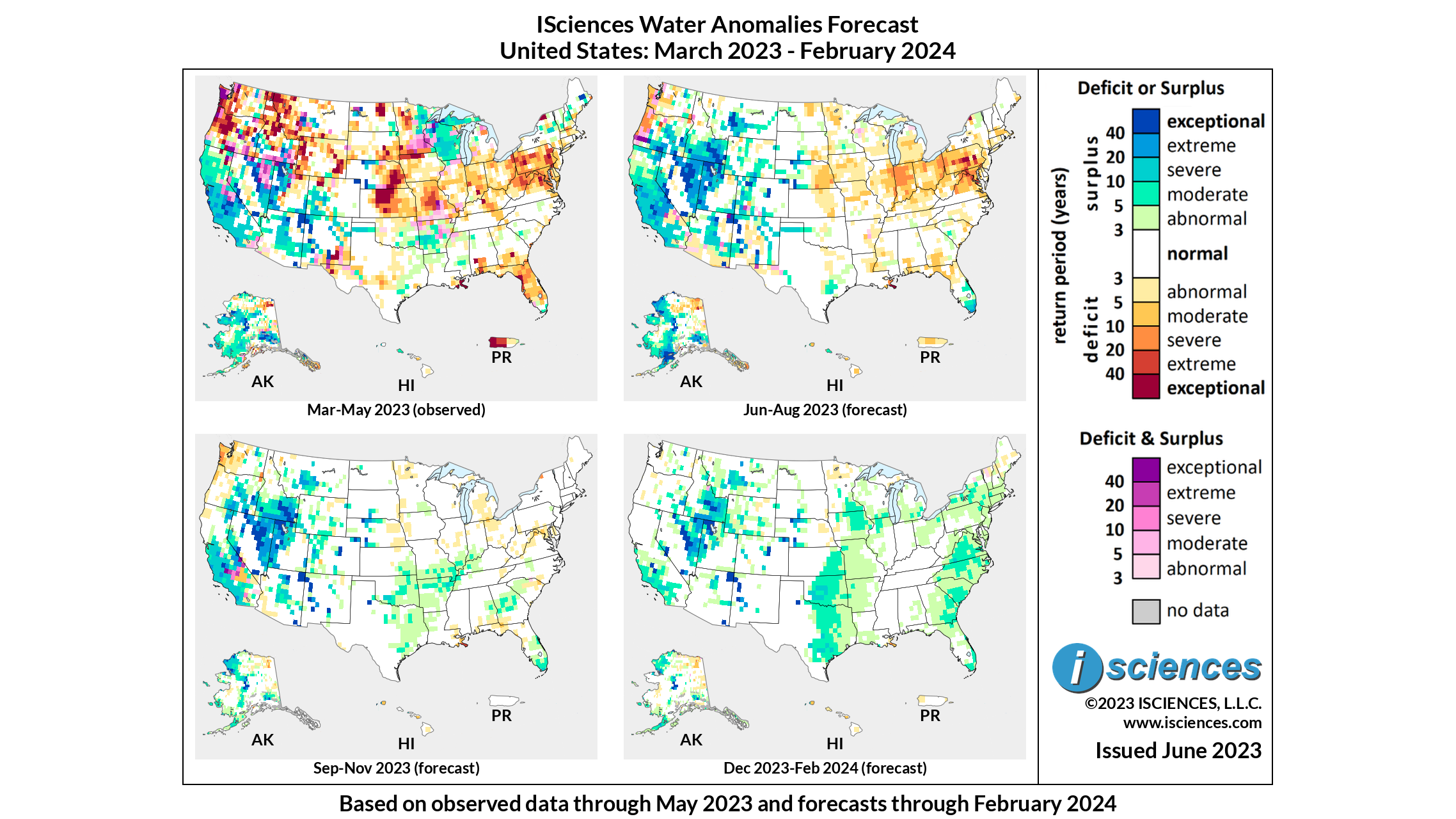
FORECAST BREAKDOWN
The forecast through August 2023 anticipates widespread deficits, of mostly severe to extreme intensity, to arise throughout the northeast. Affected areas include Indiana, Ohio, Pennsylvania, northern Virginia, and Maryland. Extreme to exceptional surpluses are expected to continue in central to southern California, central to northeastern Nevada, and southern Idaho. Other lingering surplus anomalies include central Montana, western Colorado, and Alaska.
From September through November 2023, deficits in the northeast are expected to subside. Intense surplus is expected to continue in western and southwestern states, with surplus appearing in eastern Oregon, as well as small pockets of severe deficit and transitional conditions appearing in San Bernardino County.
The forecast for the final months – December 2023 through February 2024 – expects surplus in California to lessen into moderate intensity, with extreme to exceptional surplus continuing in Nevada, Idaho, and Utah. Moderate surplus is expected to appear in east-central Texas and Oklahoma, as well as throughout most of the East Coast.
Please note that WSIM forecast skill declines with longer lead times.
IMPACTS
In California, the record-setting snowpack over the winter recharged the waterfalls in Yosemite National Park after the area’s three driest years on record. Large parts of Yosemite National Park were closed at the end of April to the public because of flooding fears, as well as from late February to mid-March, when a daily snowfall record was broken. In April, the California Department of Water Resources recorded 126.5 inches of snow and a snow water equivalent to 54 inches — a measure of how much water the snowpack actually contains. The statewide snowpack was 61.1 inches, which was 237 percent of normal for April 3.
The city of Spanish Fork in Utah ended its emergency flood declaration June 20th after seven consecutive weeks in place. The declaration was signed by the city’s mayor, Mike Mendenhall, to reallocate resources in order to prepare for flooding from spring runoff, which was especially heavy earlier this year after snowmelt left record-setting amounts of snow in mountains and canyons throughout central and northern Utah. Flooding was reported in some parts of the city and along riverbanks in Spanish Fork, but City Manager Seth Perrins stated that the city was lucky that flows never hit dangerous levels in the city.
Intense drought in Kansas is putting wheat production in the state at risk. Kansas, which is usually responsible for producing around 25 percent of the United States winter wheat crop, is experiencing the worst drought conditions seen in over a decade in large agricultural areas. The U.S. Drought Monitor data shows that as of June 20, almost 8% of the state was experiencing exceptional drought, while nearly 17% met the criteria for abnormally dry conditions. Additionally, 22.19% experienced moderate drought, 19.30% in severe drought, and 30.23% in extreme drought. This drought is assumed to be caused by low levels of rainfall and higher winds.
NOTE ON ADMINISTRATIVE BOUNDARIES
There are numerous regions around the world where country borders are contested. ISciences depicts country boundaries on these maps solely to provide some geographic context. The boundaries are nominal, not legal, descriptions of each entity. The use of these boundaries does not imply any judgement on the legal status of any territory, or any endorsement or acceptance of disputed boundaries on the part of ISciences or our data providers.
Subscribe to our monthly Water Watch List
Search blog categories
- *Precip/Temp Outlooks 101
- *Press Releases 1
- *Special Topics 16
- *Water Watch Lists 108
- Africa 117
- Australia & New Zealand 102
- Canada 103
- Central Asia & Russia 101
- East Asia 101
- Europe 108
- Mexico & C. Amer. & Carib 106
- Middle East 110
- South America 115
- South Asia 106
- Southeast Asia & Pacific 110
- United States 107
Search blog tags