

United States: Intense surplus continues in SW, W states
21 July 2023
THE BIG PICTURE
The 12-month forecast ending in March 2024 anticipates widespread surpluses in western and southwestern states to continue, with some intense deficit anomalies appearing in the Pacific Northwest and northern states of the Midwest.
The following states are expected to experience severe to exceptional surplus:
Central California, widespread throughout the Sierra Nevada.
Nevada, widespread throughout the state’s southwestern and central regions. The highest concentrations are expected south and southwest of Pyramid Lake.
Southwestern Utah, throughout Iron and Washington County. Anomalies continue south into northwestern New Mexico, into the Navajo Nation Off-Reservation Trust Land.
Central Montana, near Judith Basin County, into central Wyoming, in surrounding areas of the town of Burlington.
Alaska, across the state’s northern areas. The highest concentrations are expected near Bering Land Bridge National Preserve and the Arctic National Wildlife Refuge.
Severe to exceptional deficits are predicted in the following states:
Western Oregon and western Washington, throughout the Cascade Range and Coast Range regions.
Eastern to northeastern Minnesota, in areas east of Mille Lacs Lake, moving north into northeastern Koochiching County.
Southern Louisiana, within the Vermilion Parish. Similar anomalies reappear further north, near Davis Island.
Northwest Montana, near the Blackfeet Indian Reservation.
Transitional conditions are expected to emerge in:
Northern Wisconsin, across Oneida and Bayfield County.
Eastern Minnesota, near the Superior National Forest.
The 3-month maps (below) show the evolving conditions in more detail.
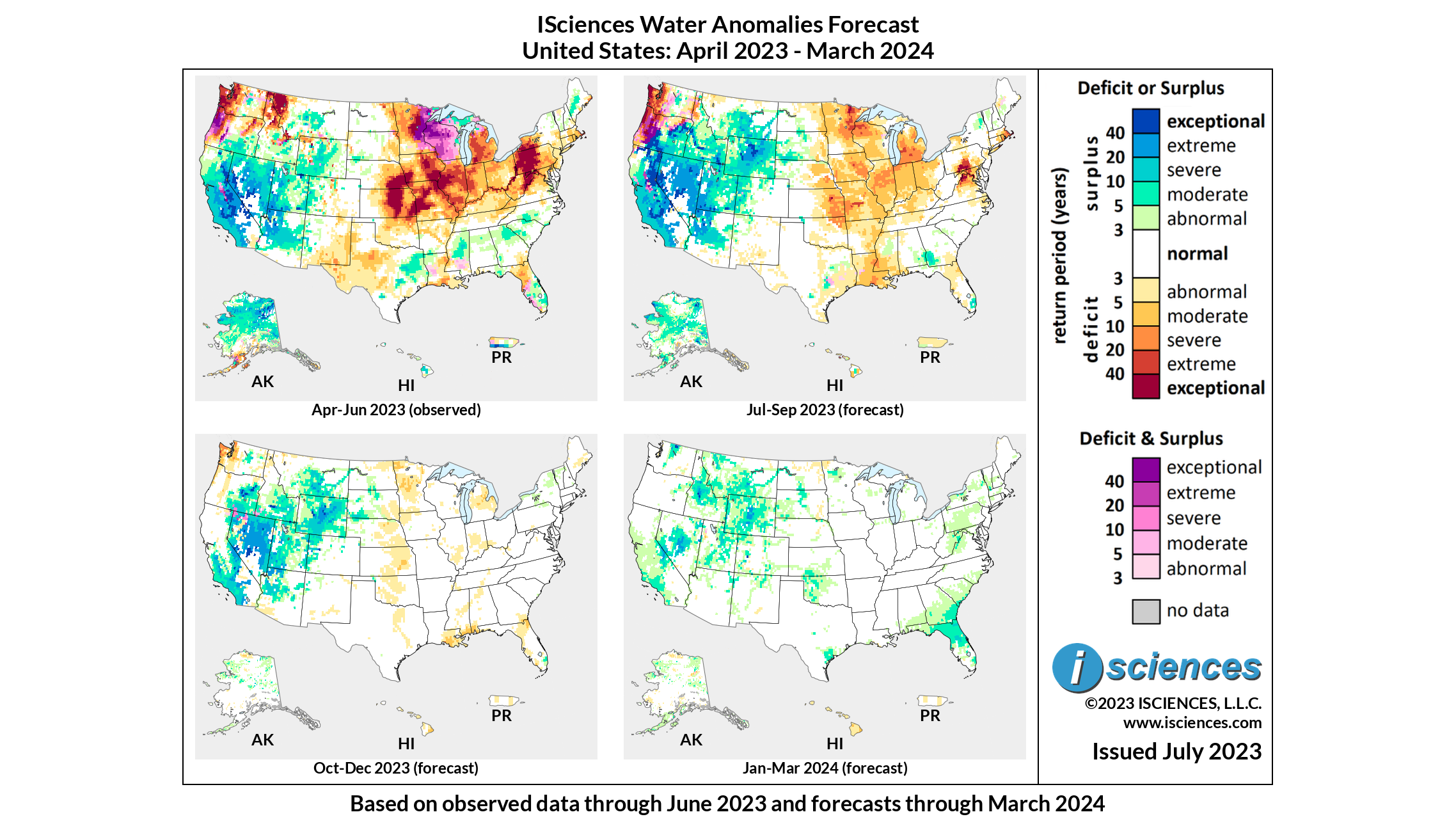
FORECAST BREAKDOWN
The forecast through September 2023 anticipates moderate to severe deficits to intensify throughout much of the Midwest, with areas of eastern Minnesota, northern Virginia, Michigan, and southern Pennsylvania experiencing severe to exceptional deficits. Exceptional deficits are also expected to continue in the Coast and Cascade Ranges, with some intense transitional conditions appearing in western Washington. Extreme to exceptional surplus is expected to endure in California, Nevada, Utah, Wyoming, Idaho, and New Mexico, which is expected to expand into eastern Washington. Outside of the Continental U.S., surplus in Alaska is expected to persist but lessen in intensity to mostly moderate to severe anomalies.
From October through December 2023, intense deficits in the Midwest are expected to diminish, becoming mostly normal conditions and mild deficit anomalies. Surpluses in most of the western and southwestern states are expected to continue, with the most concentrated areas appearing in northern to central Nevada and southern to central California. Deficits in the Pacific Northwest are predicted to lessen, with some severe to extreme deficits lingering in western Oregon.
The forecast for the final months – January 2024 through March 2024 – anticipates most deficits to disappear, with moderate surpluses continuing in central Nevada, central Idaho, central Wyoming, and appearing in northern Florida.
Please note that WSIM forecast skill declines with longer lead times.
IMPACTS
A flash flood in Bucks County, Pennsylvania caused downpours and flash flooding on July 16th, killing at least five people. Upper Makefield Township Fire Chief Tim Brewer stated that the torrent brought nearly 7 inches of rainfall to the area in just 45 minutes, and that five lives were lost. Two children, one two years old and the other 9 months were also lost during the flood. "We continue to look for the two children," Brewer said. "We are not going to give up regardless. The weather is a factor but at this point we are going to continue the operations and have already set things in motion for tomorrow as well." As of July 20th, the children remain missing.
On July 19th, cleanup after the devastating flooding of Montpelier, Vermont was interrupted by another deluge, washing out more than 100 roads in the already-submerged areas around Montpelier and Barre. The initial flood, which occurred due to the Winooski River overflowing, was considered one of the worst natural disasters the area had seen since 1927, with reports of total rainfall as much as 9.2 inches in some areas. Hundreds of water rescues took place throughout the state, with one fatality reported in Barre.
Communities in Lyon County, Nevada are reinforcing the Walker River’s banks after a record-breaking water season. While county officials acknowledge the immediate action residents and emergency management agencies took to reduce the threat, they say more is needed to keep roads and infrastructure intact from future weather events. Major roadways which were deemed impassable due to flooding in late May are still closed, and more are still in danger of being flooded. “Our primary focus has been protecting those folks (in Yerington), life safety issues and also securing the sewer system from inflowing inundation for several weeks,” Lyon County emergency and communications manager Taylor Allison said last month. “We haven’t seen major impacts to the city’s sewer system, which has been great.”
Many areas of Texas are experiencing extreme heatwaves and diminishing water resources. Temperatures throughout various counties are reaching triple digits, and communities in Texas Hill Country reportedly have less than 45 days of water supply as of July 20th. As a result, Texan officials have introduced water consumption restrictions for customers in Comal, Blanco, Kendall, Bandera, and Medina counties. According to the National Integrated Drought Information System, an estimated 11.3 million residents across 149 counties are currently experiencing drought conditions in Texas.
NOTE ON ADMINISTRATIVE BOUNDARIES
There are numerous regions around the world where country borders are contested. ISciences depicts country boundaries on these maps solely to provide some geographic context. The boundaries are nominal, not legal, descriptions of each entity. The use of these boundaries does not imply any judgement on the legal status of any territory, or any endorsement or acceptance of disputed boundaries on the part of ISciences or our data providers.
Subscribe to our monthly Water Watch List
Search blog categories
- *Precip/Temp Outlooks 101
- *Press Releases 1
- *Special Topics 16
- *Water Watch Lists 108
- Africa 117
- Australia & New Zealand 102
- Canada 103
- Central Asia & Russia 101
- East Asia 101
- Europe 108
- Mexico & C. Amer. & Carib 106
- Middle East 110
- South America 115
- South Asia 106
- Southeast Asia & Pacific 110
- United States 107
Search blog tags