

Australia & New Zealand: Surpluses in N, SE Australia to diminish
25 October 2023
THE BIG PICTURE
The 12-month forecast ending in June 2024 anticipates existing widespread surpluses to subside in most regions, though surpluses of lesser intensity will remain in northeastern and northwestern Australia.
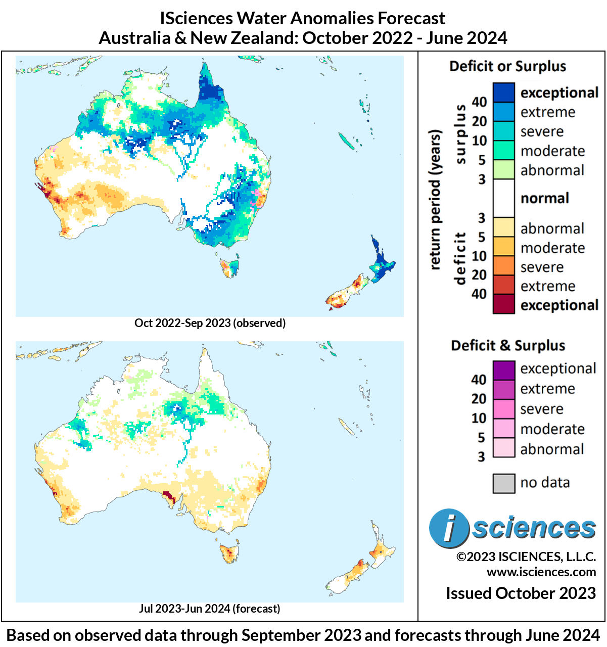
The map on top depicts long-term deficit and surplus anomalies as of September 2023, while the map on the bottom depicts a forecast of long-term deficit and surpluses as of June 2024.
Moderate to severe surpluses are expected in the following regions:
Eastern and southwestern Northern Territory, in regions south of the Barkly Tableland and northwest of the MacDonnell Ranges.
Western Queensland, in areas surrounding the Selwyn Range, as well as further south into southwestern regions of the Shire of Diamantina.
Northern regions of the Great Sandy Desert in Western Australia.
Deficits of varying intensity are expected in the following areas:
Western coastal regions of Western Australia, with moderate to severe deficits appearing near the city of Geraldton.
Southern South Australia, with isolated pockets of exceptional deficits in eastern coastal regions of the Spencer Gulf.
Eastern coastal regions of New South Wales, with moderate to severe deficits occurring near the Great Sandy National Park.
Northernmost regions of the South Island in New Zealand, with severe to extreme anomalies, as well as western coastal areas of the Taranaki region in the country’s North Island.
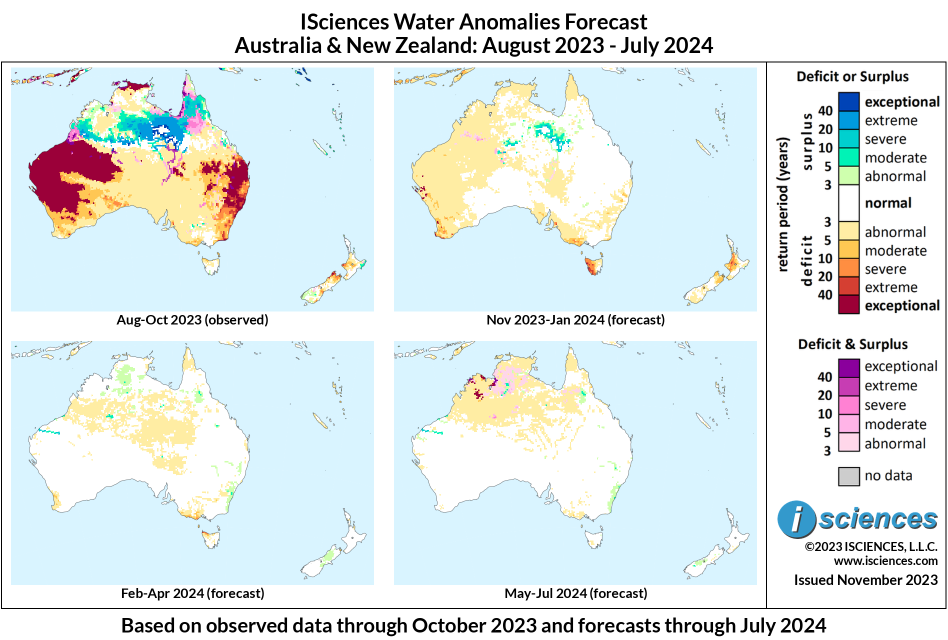
The 3-month maps (below) show the evolving conditions in more detail.
FORECAST BREAKDOWN
The forecast through December 2023 anticipates surplus across western Queensland, eastern and eastern Northern Territory, and northern Western Australia to continue. Specifically, southwestern to central areas of the Yorke Peninsula, into the Shire of Burke, and across central Northern Territory into areas of Western Australia near Eighty Mile Beach. Deficits are expected to persist in Western Australia near the Toolonga Nature Reserve, as well as in New South Wales, north of Sydney. Tasmania can expect moderate to severe deficits to emerge in its western and central regions, as well as northern areas in the North Island of New Zealand.
From January through March 2024, water anomalies are expected to considerably diminish across much of Australia. Severe to extreme surpluses are expected to continue in areas near the Eighty Mile Beach in Western Australia, as well as in southwestern regions of Queensland, in the Shire of Diamantina. Further north, southern regions of the Yorke Peninsula are expected to observe continued surplus, but will downgrade to moderate intensity. Moderate to severe deficits are expected to appear across Tasmania.
The forecast for the final months – April 2024 through June 2024 – anticipates anomalies to further subside, with near normal conditions throughout much of the area. Small pockets of intense surplus are anticipated to continue near the Eighty Mile Beach, as well as further inland in the company town of Telfer.
Please note that WSIM forecast skill declines with longer lead times.
IMPACTS
On October 4th, less than 24 hours after citizens of Australia’s state of Victoria were evacuated due to bushfires, authorities warned of intense flash flooding throughout nearly 17,000 hectares of land forecast through the following afternoon. First responders were deployed, who rescued a farmer in the area who got trapped after driving through the flood. In Gippsland, a southeastern rural region of Victoria, hundreds of firefighters spent several days battling major fires which caused evacuations and destroyed at least one home. Parts of Victoria observed up to 150 mm of rain, which is nearly eight times average for the state in September.
As the National Institute of Water and Atmospheric Research (NIWA) declared the official arrival of El Niño, farmers in Hawke's Bay braced for potential drought. New Zealander Marcus Buddo stated that "I'm worried as we all know how fast the water comes out of [the] ground and out of soil. The problem with a drought is it's insidious, it creeps up on you and every day is another day closer to rain but you have no idea how far away that is," he said. The NIWA anticipates below-average rainfall for the next next three months for the northeastern parts of the country.
A new Australian-led study reported that people have an increased likelihood of dying from heart or lung disease from three to six weeks after a natural disaster. This is expected to be a result of reduced access to health services caused by road closures, as well as exposure to black mold and other contaminants. Floods account for 43% of all extreme disaster events and are projected to increase in severity, length, and frequency due to global warming. The study stated that the risk of dying increased by 2.1% for all deaths, 2.6% for deaths from cardiovascular complications, and 4.9% for respiratory complications. The researchers collected data from 761 communities across 34 countries and territories, including Australia, all of which had experienced at least one flood during 2000 to 2010, with 11.1 million observed cardiovascular deaths and 4.9 million respiratory deaths, which were matched to flood and temperature data over the same period.
NOTE ON ADMINISTRATIVE BOUNDARIES
There are numerous regions around the world where country borders are contested. ISciences depicts country boundaries on these maps solely to provide some geographic context. The boundaries are nominal, not legal, descriptions of each entity. The use of these boundaries does not imply any judgement on the legal status of any territory, or any endorsement or acceptance of disputed boundaries on the part of ISciences or our data providers.
Subscribe to our monthly Water Watch List
Search blog categories
- *Precip/Temp Outlooks 101
- *Press Releases 1
- *Special Topics 21
- *Water Watch Lists 134
- Africa 130
- Australia & New Zealand 114
- Canada 116
- Central Asia & Russia 114
- East Asia 115
- Europe 121
- Impact Highlights 1
- Mexico & C. Amer. & Carib 119
- Middle East 124
- Proof Point 2
- South America 130
- South Asia 120
- Southeast Asia & Pacific 123
- United States 120
Search blog tags