
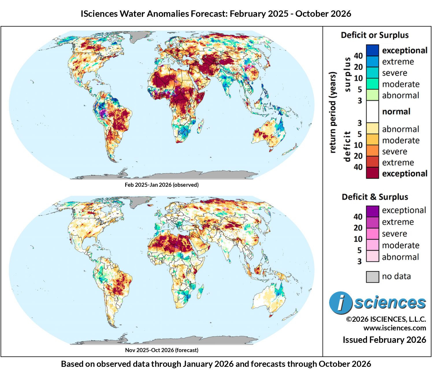
These maps present regions currently experiencing long-term (12 month) anomalies using observed temperature and precipitation data from February 2025 through January 2026 (top) and regions likely to encounter significant water anomalies during the one-year period beginning in November 2025 and running through October 2026 using 3 months of observed data and 9 months of forecast data (bottom).
The synopsis that follows provides highlights of regional water forecasts. Regional details are available in ISciences Global Water Monitor & Forecast Watch List February 13, 2026 (pdf).
United States: Observed long-term conditions (Feb 2025-Jan 2026) show continued severe to exceptional deficits in the northeast and southwest in localized areas of Nebraska, Wyoming, Colorado, Texas, New Mexico, Arizona, and Nevada. Recently observed conditions (Nov 2025-Jan 2026) show severe to exceptional deficits across most of the eastern half of the country. Areas of note across the Northeast include the Maine coast, central Pennsylvania, western lower Michigan, and central Indiana. Severe to exceptional deficits were observed throughout much of the southeast including the entire Gulf coast from the southern tip of Texas up to New Orleans and down to Naples, Florida. Exceptional deficits were observed in the Piedmont region of Alabama and Georgia. Additional pockets of severe deficits were observed across the central plains in the Nebraska-Colorado-Wyoming border, and around the New Mexico-Texas-Oklahoma-Colorado border. In contrast, exceptional surpluses persist across western and northern Alaska, while moderate to extreme surpluses were observed in eastern Washington, northern Idaho, and western Montana heading south along the Nevada-California border and terminating in the greater Los Angeles area.
The forecast (Nov 2025-Oct 2026) indicates significant improvement in long-term conditions across most of the country. Mostly near-normal conditions are expected in the eastern half of the country by May 2026, while abnormal to severe conditions will persist in the western half of the country. Pockets of extreme to exceptional deficits are forecast for central Wyoming, northern Idaho, central Washington, and northeast Oregon through October 2026.
Canada: Observed long-term conditions (Feb 2025-Jan 2026) show exceptional deficits across the Prairie Provinces, with the most intense conditions covering central Alberta north of Edmonton, extending through Saskatchewan and into western Manitoba near Lake Winnipeg. Severe to exceptional deficits also extend from Northeastern British Columbia into the Northwest Territories. The Atlantic provinces including Nova Scotia, New Brunswick, Prince Edward Island, and southern Newfoundland show severe to exceptional deficits. In contrast, northern Quebec and coastal Labrador display moderate to severe surpluses, with additional surplus conditions in the far northern territories.
The forecast (Nov 2025-Oct 2026) indicates gradual improvement in long-term conditions across most of Canada. Prairie deficits are expected to reduce in extent but persist at moderate to severe levels in central Saskatchewan and parts of Alberta through April 2026, diminishing further by summer. Deficits northeast of Great Bear Lake are also expected to persist into summer 2026. Atlantic province deficits are expected to diminish. Most of the country is forecast to approach near-normal conditions by Aug-Oct 2026, with residual moderate deficits potentially lingering in the central prairies.
Mexico, Central America, and the Caribbean: Observed long-term conditions (Feb 2025-Jan 2026) show moderate to severe deficits across northern Mexico including Baja California, Sonora, and Chihuahua, extending east through Coahuila and Nuevo León toward Monterrey. The most severe deficits were observed along the Chihuahua-Coahuila border. Central Mexico near Mexico City and Guadalajara displays mixed deficit and surplus conditions. In the Caribbean, western Cuba experienced severe to exceptional deficits, while eastern Cuba and Jamaica display more mixed conditions. Haiti and the Dominican Republic have moderate to exceptional deficits in the north and moderate surpluses in the south. Central America presents contrasting patterns with moderate to severe surpluses across Nicaragua, Costa Rica, and Panama, while Guatemala, El Salvador, and Honduras show moderate to exceptional deficits.
The forecast (Nov 2025-Oct 2026) indicates improvement across most of northern Mexico, with deficits moderating to abnormal levels. Moderate to severe surpluses are forecast to emerge along Mexico’s Pacific coast during May-Jul 2026. Central America surpluses are forecast to spread through Apr 2026 before returning to mostly normal conditions by May-Jul 2026. Caribbean deficits will moderate, by May-Jul 2026 most of the region transitions toward near-normal conditions.
South America: Observed long-term conditions (Feb 2025-Jan 2026) show exceptional deficits across the Amazon basin, covering an enormous area of central Brazil through the states of Amazonas, Pará, and extending south through Mato Grosso, Goiás, and into the São Paulo region. Deficits extend further south into Paraguay along the Paraná and Paraguay Rivers and into most of northern Argentina. Widespread exceptional mixed deficit and surplus conditions were observed throughout western Amazonas and Acre and exceptional surpluses stretch across the Andes through Peru, Ecuador, and Colombia. Exceptional surpluses were also observed in Venezuela along the Orinoco River basin and across Guyana and Suriname.
The forecast (Nov 2025-Oct 2026) indicates central/eastern Brazilian and Bolivian deficits will persist at severe to exceptional levels through Feb-Apr 2026 before gradually diminishing. Deficits across central Brazil are expected to decline to moderate-severe levels by May-Jul 2026, but will remain widespread. Northern surpluses will intensify throughout Colombia during Feb-Apr 2026 before returning to mostly normal conditions in Jul 2026. Severe to extreme deficits are expected to emerge in Venezuela during Aug-Oct 2026.
Europe: Observed long-term conditions (Feb 2025-Jan 2026) show moderate to exceptional deficits across most of the eastern and northern regions of the continent. Areas of intense deficits include eastern Turkey and the Romanian-Hungarian, Ukraine-Belarus-Poland, and German-Czechia border zones. Additional extreme deficits were observed in Belgium, Germany along the Elbe river, and the southern most portions of Sweden. The United Kingdom experienced severe to exceptional deficits, particularly across eastern and central England. In contrast, moderate to severe surpluses dominated the Iberian Peninsula across Spain and Portugal. Exceptional surpluses were observed in northern Scandinavia. While long-term observed conditions display widespread deficits, the recent seasonal (Nov 2025-Jan 2026) conditions were milder with a mix of moderate deficits and surpluses across most of the continent; the exception being intense extreme surpluses across the southern Balkan states.
The forecast (Nov 2025-Oct 2026) indicates significant improvement across most of the continent with a return to near-normal conditions by May 2026. However, Iceland, the Norwegian coastline and the Poland-Belarus-Ukraine border zone may see localized exceptional deficits into Jul 2026.
Africa: Observed long-term conditions (Feb 2025-Jan 2026) show severe to exceptional deficits across the West African coast from Sierra Leone through Liberia, Côte d’Ivoire, Ghana, Nigeria, and Cameroon. Exceptional deficits extend into Central Africa across the Central African Republic (CAR) and throughout much of the Democratic Republic of the Congo (DRC) along the Congo River basin. North Africa including Morocco, Mauritania, Mali, Algeria, Niger, Libya, and Egypt along the Nile showed moderate to exceptional deficits. Exceptional deficits were also observed throughout the Horn of Africa. In contrast, a prominent band of surpluses stretched across the Sahel from Senegal through southern Mali, Burkina Faso, Niger, and into Chad. Northern South Africa, Botswana, Zimbabwe, Mozambique, and Zambia display moderate to severe surpluses.
The forecast (Nov 2025-Oct 2026) indicates West African coastal deficits will diminish but persist at moderate to severe levels through April 2026 before further improvement. DRC and CAR deficits will persist in smaller pockets before recovery to normal conditions in May-Jul 2026. Sahel surpluses expand eastward beginning May-Oct 2026, and southern African surpluses will initially reduce in area Feb-Apr 2026, but persist through the remainder of the forecast period.
Middle East: Observed long-term conditions (Feb 2025-Jan 2026) show widespread exceptional deficits across large sections of the region. Iran endured exceptional deficits throughout virtually the entire country. Southeastern Turkey, Syria, and northern Iraq also experienced exceptional deficits. Lebanon, Jordan, and Israel showed severe to exceptional deficits. The Arabian Peninsula experienced moderate to severe deficits across Saudi Arabia, with exceptional conditions around Mecca moving east into central regions. Oman and UAE displayed moderate to exceptional deficits. Recent seasonal conditions (Nov 2025-Jan 2026) showed some relief across the region with exceptional deficits being limited to eastern Egypt and eastern Turkey tracking to the southern border of the Caspian Sea.
The forecast (Nov 2025-Oct 2026) indicates significant improvement across much of the region by Feb-Apr 2026. Iran is expected to return to mostly abnormal deficits and scattered moderate surpluses in the east. Similarly, Iraq, Syria, and Turkey will transition to mostly moderate deficits with pockets of severe to exceptional deficits. Eastern Turkey will transition from deficits to moderate surpluses.
Central Asia and Russia: Observed long-term conditions (Feb 2025-Jan 2026) show exceptional deficits across Central Asia including Kazakhstan, Uzbekistan, Turkmenistan, Tajikistan, and Kyrgyzstan. Particularly intense conditions were observed around the Aral Sea basin moving southwest to the Caspian Sea and along the Amu Darya and Syr Darya river systems. Western Russia experienced moderate to severe deficits. In contrast, eastern Siberia and Russia’s Far East displayed moderate to exceptional surpluses.
The forecast (Nov 2025-Oct 2026) indicates gradual improvement across Central Asia, with deficits expected to diminish from exceptional to moderate-severe levels by Feb-Apr 2026. However, the southern Central Asian countries including Turkmenistan and Uzbekistan are expected to retain more intense deficits around Sarygamysh Lake through mid-2026. Western Russia will transition toward near-normal conditions, but moderate to severe surpluses are expected to emerge around the Altai Republic and Central Asian Range Feb-Apr 2026.
South Asia: Observed long-term conditions (Feb 2025-Jan 2026) continue to show widespread surpluses across much of India, with exceptional conditions in southern states throughout the Krishna River Basin, central northern regions in Madhya Pradesh, and in the northeast in the Ganges River Basin heading into Bihar. Moderate to exceptional deficits were observed in Bhutan and India’s state of Arunachal Pradesh. Western Pakistan and Afghanistan show severe to exceptional deficits, while eastern Pakistan along the Indus River valley displays moderate surpluses. Nepal also exhibited surpluses along the Chinese border. Sri Lanka shows moderate to severe surplus conditions. Recent seasonal conditions (Nov 2025-Jan 2026) confirm the Indian surpluses remain prominent across peninsular India.
The 12-month forecast (Nov 2025-Oct 2026) indicates Indian surpluses will persist through Feb-Apr 2026 before gradually diminishing. Near-normal to abnormal deficit conditions are expected throughout the entire region by mid summer 2026.
Southeast Asia and the Pacific: Observed long-term conditions (Feb 2025-Jan 2026) show exceptional surpluses across the Philippines, Myanmar surrounding the Mobye Reservoir, and much of northern Vietnam. Northern Sumatra and Malaysian Borneo experienced severe to exceptional deficits. Eastern Indonesia including Sulawesi and Papua shows moderate to exceptional surplus conditions.
The 12-month forecast (Nov 2025-Oct 2026) indicates Philippine surpluses will diminish significantly by May-Jul 2026. Moderate to extreme deficits are expected to persist in northern Sumatra and Borneo, while new deficits emerge in Sulawesi and the entirety of Papua and Papua New Guinea.
East Asia: Observed long-term conditions (Feb 2025-Jan 2026) show widespread contiguous exceptional deficits across Xinjiang and Western Mongolia extending into localized pockets across north-central China. A large band of mixed conditions was observed across central China starting from Shandong by the Yellow Sea and moving south and west through Henan, Hubei, and Chongqing. Modest surpluses were observed along the western Sichuan and Tibetan Plateau. Southeastern Chinese coastal provinces west and south of Shanghai display moderate to exceptional deficits. Japan experienced widespread severe to exceptional deficits across much of the country. South Korea remained mostly near-normal with scattered moderate anomalies. Recent seasonal conditions (Nov 2025-Jan 2026) present a notably different picture, with moderate to extreme surpluses emerging across western Tibet, west of Beijing, and in the Yunnan province, but with moderate to exceptional deficits in the southeastern provinces west of Shanghai.
The forecast (Nov 2025-Oct 2026) indicates modest Mongolian deficits will persist through Spring 2026, while central-eastern Chinese surpluses gradually retreat by May-Jul 2026. Japan, Taiwan, and the Korean Peninsula are expected to approach near-normal conditions through October 2026.
Australia & New Zealand: Observed long-term conditions (Feb 2025-Jan 2026) show moderate to exceptional surpluses across northern Australia including the Northern Territory and northern Queensland extending south into the Lake Eyre watershed, and coastal areas north and south of Sydney. Central and western Western Australia displays widespread deficit conditions, with pockets of severe to exceptional deficits surrounding Shark Bay and extending east into the Western Plateau. Victoria near Melbourne shows moderate to severe deficits. Tasmania experienced severe to exceptional deficits across the island. New Zealand showed a mix of abnormal to moderate surplus and deficit conditions. Recent seasonal conditions (Nov 2025-Jan 2026) highlight intensified exceptional deficits in Tasmania and Victoria, but a weakening of deficit conditions in the western half of the country.
The forecast (Nov 2025-Oct 2026) indicates northern surpluses will persist through mid-2026, continuing to extend south into the Lake Eyre basin. Victorian deficits are expected to improve by Feb-Apr 2026. Western Australian deficits will moderate to normal conditions. New Zealand is to approach near-normal conditions.