
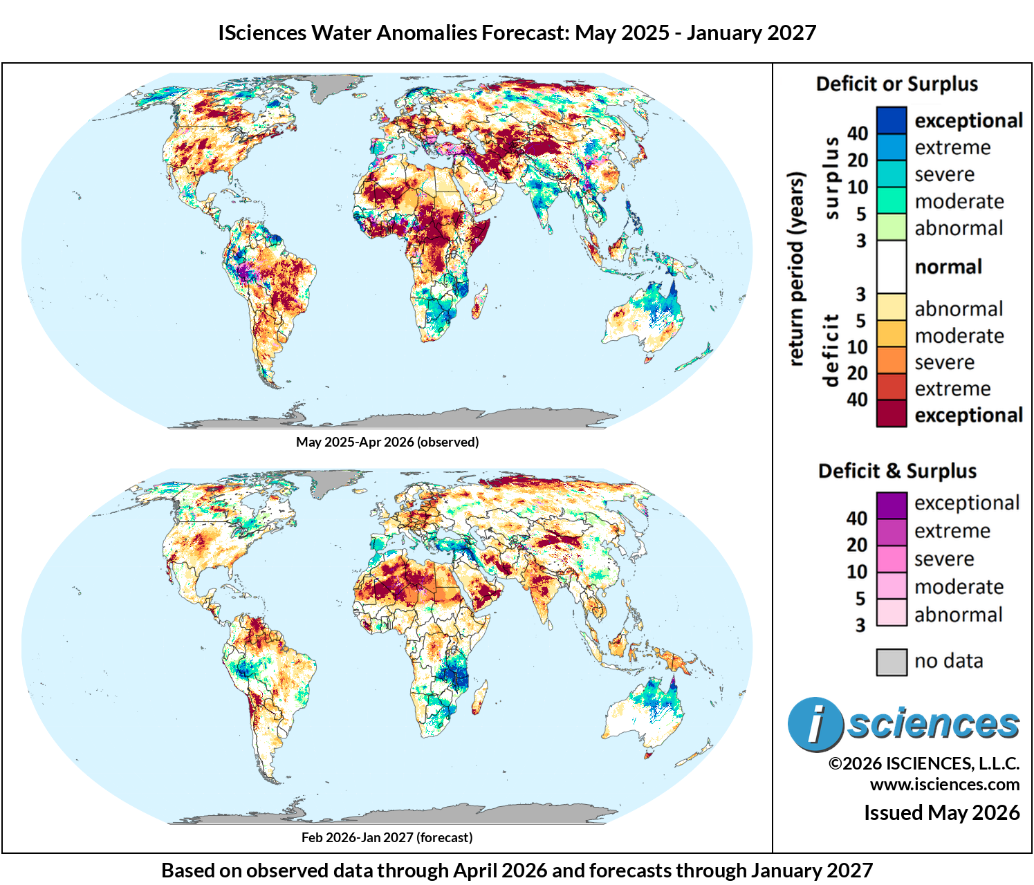
These maps present regions currently experiencing long-term (12 month) anomalies using observed temperature and precipitation data from May 2025 through April 2026 (top) and regions likely to encounter significant water anomalies during the one-year period beginning in February 2026 and running through January 2027 using 3 months of observed data and 9 months of forecast data (bottom).
The synopsis that follows provides highlights of regional water forecasts. Regional details are available in ISciences Global Water Monitor & Forecast Watch List May 15, 2026 (pdf).
In Focus: An Impending Super El Niño
NOAA recently announced the possibility of an emerging Super El Niño during the 2026 summer and fall seasons. It has the potential to be one of the strongest on record; equatorial Pacific sea surface temperatures are projected to exceed 2.7°C above average. The impacts will be felt worldwide, but the outcomes will vary by region. For the American Southeast currently ravaged by wildfires, it signals potential relief. For South and Southeast Asia, it threatens to suppress the important monsoon season.
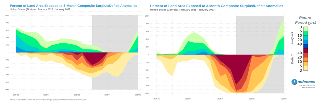
The southeastern United States entered spring 2026 in the midst of one of its most severe droughts since records began. By mid-April, nearly all of Florida and Georgia — 98–99% of each state — were under drought conditions, with precipitation deficits of 8 to 16 inches accumulated since July 2025 and September 2025 through March 2026 ranking as the driest such stretch going back to 1895. The consequences were have been severe: wildfires swept through tens of thousands of acres along the Georgia-Florida border in late April, destroying more than 120 homes across Brantley County and adjacent communities, while smoke pushed air quality alerts as far north as Atlanta. ISciences’ Water Security Indicator Model (WSIM) indicates that more than 80% of Georgia and 40% of Florida’s land area is under exceptional water deficit (below). But the developing super El Niño may bring a dramatic shift for the region’s water future by fall 2026. El Niño characteristically drives wetter winters across the American Southeast by shifting storm tracks southward along a strengthened subtropical jet stream. This effect is expected to be even greater with a Super El Niño: historical data shows Florida averages 23.3 flood events annually during El Niño years compared to just 4.9 during neutral years, with winter rainfall in some areas running 5 inches or more above normal.
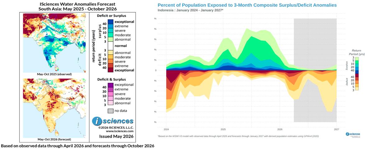
The opposite effect is expected across South and Southeast Asia, where two of the world’s largest populations rely on monsoon rains arriving reliably each May through October. In India, the southwest monsoon provides roughly 70% of the country’s annual rainfall and sustains the kharif agricultural season on which approximately 60% of Indian farmers depend. Forecasts for 2026 indicate a large shift from 2025. The India Meteorological Department projects cumulative monsoon rainfall at approximately 94% of the long-period average, with a 35% probability of outright deficient rainfall — more than double the historical baseline of 16%. The 2015–16 super El Niño offers a sobering precedent: rainfall reached only 86% of normal that year, triggering widespread drought. WSIM forecasts show central and peninsular India covered in exceptional surpluses during May–October 2025, while the same period in 2026 is forecast to be dominated by moderate to extreme deficits. Our seasonal South Asia Regional Forecast shows the Indus basin border region is expected to be under widespread exceptional deficits by Nov 2026-Jan 2027. This is a concerning forecast given India’s suspension of the Indus Waters Treaty following the April 2025 Kashmir attack.
University of Gadjah Mada forestry researchers have warned that the drying conditions — combined with ongoing slash-and-burn land clearing practices — risks repeating Indonesia’s catastrophic 2015 fire season, when peatland fires covered Southeast Asia in haze for months, with severe health, aviation, and economic consequences. For India and Indonesia, the monsoon season is fundamental to food security, water availability, and ecological stability, and the super El Niño may present a significant disruption.
Sources:
Super El Niño Increasingly Likely, Could Be Record Strong. The Weather Channel, May 7, 2026.
Drought Status Update for the Southeast. Drought.gov, April 16, 2026.
Wildfires across Georgia and Florida destroy more than 50 homes and force evacuations. CNBC, April 26, 2026.
El Niño and its Effect on the Southeast U.S.. NOAA National Weather Service.
How El Niño-driven weaker monsoon rains could impact India. Reuters, April 16, 2026.
Super El Niño 2026: Will India Face a Weak Southwest Monsoon and Rainfall Deficit?. Down to Earth, 2026.
What to Know About Pakistan’s Ongoing Water Crisis. TIME, 2026.
Indonesia’s Forest at Risk of Wildfire from El Niño. Universitas Gadjah Mada, 2026.
Regional Synopsis
This synopsis provides highlights of regional water forecasts. More detailed analysis is available in “Watch List: Regional Details” immediately following the synopsis.
United States: Observed long-term conditions (May 2025–Apr 2026) show severe to exceptional deficits dominating the central and southern Plains extending through the Southwest along the Colorado River basin, and New England. Moderate to severe surpluses cover Washington, Oregon, and most of Alaska. The 12-month forecast (Feb 2026–Jan 2027) indicates improvement in the Southern Plains, New England, Southwest, and Southeast by mid-2026. The Southeast is expected to transition toward surpluses by late 2026.
Canada: Observed long-term conditions (May 2025–Apr 2026) show severe to exceptional deficits across the Prairie provinces — Alberta, Saskatchewan, and Manitoba — and the Atlantic provinces, while northern Quebec and Nunavut display notable surpluses. The 12-month forecast (Feb 2026–Jan 2027) indicates gradual Prairie improvement through mid-2026, with Atlantic provinces approaching near-normal by summer and most of the country trending toward mixed normal-to-moderate conditions by late 2026.
Mexico, Central America, and the Caribbean: Observed long-term conditions (May 2025–Apr 2026) show scattered severe to exceptional deficits across northern Mexico and moderate to exceptional surpluses surrounding Mexico City. Nicaragua, Costa Rica, and Panama display moderate to severe surpluses. The 12-month forecast (Feb 2026–Jan 2027) indicates northern Mexico deficits moderating toward moderate levels by mid-2026, and Central American surpluses transitioning to moderate to exceptional deficits by late 2026.
South America: Observed long-term conditions (May 2025–Apr 2026) show exceptional surpluses across northwestern South America — Colombia and Venezuela along the Orinoco basin into Guyana and Suriname — contrasting with severe to exceptional deficits across central Brazil (Mato Grosso, Goiás, Minas Gerais) and the Paraná River corridor into Paraguay and northeastern Argentina. The 12-month forecast (Feb 2026–Jan 2027) indicates northwestern surpluses moderating by mid-2026, and central Brazilian deficits easing by late-2026.
Europe: Observed long-term conditions (May 2025–Apr 2026) show surpluses across Scandinavia and the British Isles contrasting with moderate to exceptional deficits across central and eastern Europe — Germany along the Rhine, Poland, Czechia, Hungary, Romania, and into Ukraine — with recent conditions (Feb–Apr 2026) intensifying both patterns. The 12-month forecast (Feb 2026–Jan 2027) indicates northern surpluses moderating through mid-2026 while central European deficits expand through summer before easing by late 2026.
Africa: Observed long-term conditions (May 2025–Apr 2026) show severe to exceptional deficits along the West African coastal zone, the central regions of the northwest, and across the DRC along the Congo River basin. However, recent conditions (Feb-Apr 2026) illustrate near normal deficits in the north and a lessening of deficits in the west and central regions. Broad moderate surplus band extends through the Sahel and southern Africa (Zambia, Zimbabwe, Mozambique). The 12-month forecast (Feb 2026–Jan 2027) indicates West African and DRC deficits moderating while exceptional deficits emerge throughout the Saharan through mid-2026, Sahel surpluses strengthening through the Aug–Oct rainy season, and southern African surplus conditions persisting through late 2026.
Middle East: Observed long-term conditions (May 2025–Apr 2026) show severe to exceptional deficits across Iran, Iraq, Syria, Lebanon, Jordan, and Israel, with mostly moderate to severe deficits across Saudi Arabia and exceptional deficits in western Yemen; recent conditions (Feb–Apr 2026) show a dramatic reversal in the northern sub-region, with exceptional surpluses emerging across Turkey and northern Iraq and Syria. The 12-month forecast (Feb 2026–Jan 2027) indicates continued improvement across Iran and the Levant through mid-2026, while exceptional deficits are expected to develop and persist across the southern Arabian Peninsula through late 2026.
Central Asia and Russia: Observed long-term conditions (May 2025–Apr 2026) show exceptional deficits dominating Kazakhstan, Uzbekistan, Turkmenistan, Tajikistan, and Kyrgyzstan around the Aral Sea basin and along the Amu Darya and Syr Darya river systems. Northern and eastern Siberia display moderate to severe surpluses. The 12-month forecast (Feb 2026–Jan 2027) indicates gradual improvement across Kazakhstan beginning by mid-2026 and easing through the Amu Darya and Syr Darya basin states by late 2026, while moderate to severe deficits are expected to spread across central and northern-central Russia through the forecast period. Moderate to exceptional surpluses are expected to emerge in the Uzbekistan-Tajikistan-Kyrgyzstan border region during Nov 2026-Jan 2007.
South Asia: Observed long-term conditions (May 2025–Apr 2026) show a large contiguous block of exceptional surpluses across central and peninsular India with moderate surpluses in eastern Pakistan along the Indus valley, and moderate to severe deficits in western Pakistan and Afghanistan. The 12-month forecast (Feb 2026–Jan 2027) indicates Indian surpluses diminishing through mid-2026, transitioning toward moderate deficits by Aug–Oct 2026, and intensifying to exceptional deficit conditions in the Pakistan-India border region by Nov 2026–Jan 2027.
Southeast Asia and the Pacific: Observed long-term conditions (May 2025–Apr 2026) show exceptional surpluses across most of the Philippines, Papua and the Papua New Guinea border region, and the eastern mainland (Vietnam, Laos, Cambodia). Conversely, northern Sumatra and Malaysian Borneo experienced moderate to severe deficits. The 12-month forecast (Feb 2026–Jan 2027) indicates nearly the entire region will be under moder to extreme deficits by Aug-Oct 2026 with the most severe conditions present across the entire island of New Guinea.
East Asia: Observed long-term conditions (May 2025–Apr 2026) show severe to exceptional deficits across a large contiguous block spanning western Mongolia and northwestern China along with moderate to severe deficits across southeastern China south of Shanghai through Fujian and Guangdong, while moderate to severe surpluses occupy the Yellow River basin west of Beijing and the southern provinces of Yunnan and Guangxi. The 12-month forecast (Feb 2026–Jan 2027) indicates southeastern China deficits transitioning toward moderate surpluses through mid-2026, with most of the region approaching near-normal by Aug–Oct 2026, while localized moderate to severe deficits persist in northwestern China through late 2026.
Australia & New Zealand: Observed long-term conditions (May 2025–Apr 2026) show moderate to severe surpluses across northern Australia — the Northern Territory and northern Queensland — while southeastern Australia, including New South Wales, Victoria, and Tasmania experiences moderate to exceptional deficits. The 12-month forecast (Feb 2026–Jan 2027) indicates northern surpluses remaining through Oct 2026, while southeastern deficits, with the exception of Tasmania, ease toward near-normal by mid-2026.