
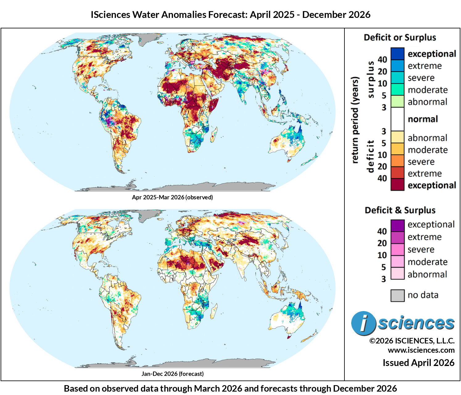
These maps present regions currently experiencing long-term (12 month) anomalies using observed temperature and precipitation data from April 2025 through March 2026 (top) and regions likely to encounter significant water anomalies during the one-year period beginning in January 2026 and running through December 2026 using 3 months of observed data and 9 months of forecast data (bottom).
The synopsis that follows provides highlights of regional water forecasts. Regional details are available in ISciences Global Water Monitor & Forecast Watch List April 15, 2026 (pdf).
United States: Observed long-term conditions (Apr 2025–Mar 2026) show large pockets of moderate to exceptional deficits across the majority of the country with the worst deficits found in the Nevada-Utah, Wyoming-Nebraska-Colorado, and Arizona-New Mexico border regions. Additional areas of extreme deficits were observed in southeastern Texas, Louisiana and southern Arkansas, central North Carolina heading north through the Virginia into the areas surrounding Erie, PA and Buffalo, NY, and northern New England and Maine. In contrast small pockets of moderate surpluses were observed in southeastern Washington, central Oklahoma, southeastern Florida and nearly all of Alaska. Recent seasonal conditions (Jan–Mar 2026) reflect a further intensification of deficits across the eastern two-thirds of the country. The 12-month forecast (Jan–Dec 2026) indicates slight improvement, with deficits moderating in the northeast and upper Midwest by Apr–Jun 2026 and most of the country trending toward near-normal by Jul–Sep 2026. Moderate to severe deficits are expected to persist across the southern plains through summer 2026, with scattered deficits remaining in the Southwest (Arizona and New Mexico), and along the California coastline into fall. Pacific Northwest surpluses are expected to moderate through mid-year.
Canada: Observed long-term conditions (Apr 2025–Mar 2026) show severe to exceptional deficits across the Prairie provinces — Alberta, Saskatchewan, and Manitoba — with the most intense exceptional conditions concentrated along the BC-Alberta border region, into central Saskatchewan, and then east to the areas surrounding Lake Winnipeg. The Atlantic provinces, including Nova Scotia, New Brunswick, Prince Edward Island, and Newfoundland, also experienced moderate to exceptional deficits. In contrast, northern Quebec, Nunavut, and coastal Labrador display notable surpluses. Recent seasonal conditions (Jan–Mar 2026) are broadly consistent with long-term patterns, with Prairie deficits persisting at severe to exceptional levels, and new deficits emerging in the Ontario-Quebec border regions. The 12-month forecast (Jan–Dec 2026) indicates gradual improvement across the Prairies, with deficits moderating in spatial extent by Apr–Jun 2026 and continuing to ease through summer while converting to moderate surpluses in some areas. Atlantic province conditions are expected to approach near-normal by mid-2026, but moderate to exceptional deficits may emerge in far northern regions summer of 2026. Most of the country is expected to be under a mix of normal and moderate deficit conditions by Oct–Dec 2026.
Mexico, Central America, and the Caribbean: Observed long-term conditions (Apr 2025–Mar 2026) show severe to exceptional deficits across northern Mexico, covering a broad contiguous area including Sonora, Chihuahua, Coahuila, and Nuevo León. Moderate to severe deficits extend through central Mexico before transitioning into mixed surplus and deficit conditions surrounding the Jalisco and Mexico City corridor. In contrast, moderate to severe deficits were observed in southern Mexico into Guatemala and Belize, while Nicaragua, Costa Rica, and Panama, display moderate to severe surpluses. The eastern Caribbean shows areas of moderate surplus, while Cuba displays moderate deficits and Hispaniola shows mixed conditions. Recent seasonal conditions (Jan–Mar 2026) are similar to long term trends, with northern Mexico deficits persisting and expanding along the northeastern coast, while southern Central America retains surplus conditions. The 12-month forecast (Jan–Dec 2026) indicates gradual improvement across northern Mexico, with deficits moderating toward normal-moderate levels by mid-2026. Central American surpluses are expected to ease moderate deficits by by summer 2026, with most of the region approaching normal conditions by Oct–Dec 2026.
South America: Observed long-term conditions (Apr 2025–Mar 2026) show exceptional surpluses dominating a large contiguous area of northwestern South America; Colombia and Venezuela along the Orinoco basin, extending into Guyana, Suriname, and French Guiana. Western Amazonia along the Peru-Ecuador-Brazil border displays extensive mixed deficit and surplus conditions. A large contiguous block of exceptional deficits covers much of central Brazil, spanning Mato Grosso, Goiás, and Minas Gerais, extending southward through the Paraná River corridor into Paraguay and northeastern Argentina near Buenos Aires. Recent seasonal conditions (Jan–Mar 2026) are broadly consistent, however, existing patterns are reduced in extent and magnitude. The 12-month forecast (Jan–Dec 2026) indicates Colombian and Venezuelan surpluses will gradually moderate through mid-2026. Central Brazilian deficits are expected to persist but ease from exceptional toward normal-moderate levels by Fall 2026. The southern cone — Argentina and Uruguay — is expected to approach near-normal conditions by mid-2026.
Europe: Observed long-term conditions (Apr 2025–Mar 2026) show a broad band of moderate to exceptional deficits across central and eastern Europe, covering Germany along the Rhine and Elbe, Poland, Czech Republic, Hungary, and Romania, extending into Ukraine and Belarus. In contrast, the southern Balkans — Greece, Bulgaria, and Serbia — display surpluses, as do northwestern Scandinavia, and the Iberian Peninsula. Recent seasonal conditions (Jan–Mar 2026) reflect moderation of deficits across central Europe, while surpluses expand in the north, west, and southern areas. The 12-month forecast (Jan–Dec 2026) indicates that existing patterns of central drought with southern/western surpluses will remain through Sep 2026, but normal to moderate conditions are expected throughout most of Europe by December 2026.
Africa: Observed long-term conditions (Apr 2025–Mar 2026) show severe to exceptional deficits along the West African coastal zone, spanning a contiguous block from Guinea and Sierra Leone through Liberia, Côte d’Ivoire, Ghana, and Nigeria into Cameroon. Severe to exceptional deficits also dominate the Democratic Republic of the Congo along the Congo River basin, extending into the Central African Republic. Moderate to exceptional deficits cover much of North Africa, including Morocco, Mauritania, Mali, Algeria, Libya, and Egypt along the Nile. In contrast, a broad surplus band runs through the Sahel from Senegal eastward through southern Mali, Burkina Faso, Niger, and Chad. Moderate to severe surpluses were also present across Zambia, Zimbabwe, and Mozambique. Recent seasonal conditions (Jan–Mar 2026) are broadly consistent with the long-term pattern, but most deficits are severely reduced in intensity and extent. The 12-month forecast (Jan–Dec 2026) indicates West African coastal deficits will gradually moderate through mid-2026, and DRC deficits will reduce in extent. Sahel surpluses are expected to return to mostly normal conditions by Sep 2026, and southern African surplus conditions are forecast to continue through 2026.
Middle East: Observed long-term conditions (Apr 2025–Mar 2026) show exceptional deficits across the entirety of Iran, with severe to exceptional deficits extending west through Iraq along the Euphrates and Tigris basins into Syria and southeastern Turkey. Lebanon, Jordan, and Israel also show severe deficits. Saudi Arabia experienced moderate to severe deficits across most of the country, with more intense conditions around Makkah and extending toward Riyadh and Kuwait. The UAE and Oman display moderate deficits across the Gulf coast and interior while exceptional deficits were present in western Yemen. Recent seasonal conditions (Jan–Mar 2026) show a dramatic reversal across the northern sub-region, with exceptional surpluses emerging across Turkey and northern Iraq and Syria, while Iran and the Arabian Peninsula retain pockets of moderate and severe deficits. The 12-month forecast (Jan–Dec 2026) indicates significant improvement across Iran and the Levant through mid-2026, transitioning toward near-normal. Large areas of exceptional defecits are expected to emerge in the southern Arabian Peninsula during Apr-Jun 2026 and are expected to retain through the rest of 2026.
Central Asia and Russia: Observed long-term conditions (Apr 2025–Mar 2026) show exceptional deficits dominating the entire Central Asian sub-region — Kazakhstan, Uzbekistan, Turkmenistan, Tajikistan, and Kyrgyzstan — with the most intense conditions concentrated around the Aral Sea basin and along the Amu Darya and Syr Darya river systems and moving southwest to the Caspian Sea. Western Russia experienced moderate deficits. In contrast, areas of northern and eastern Siberia display moderate to severe surpluses. Recent seasonal conditions (Jan–Mar 2026) anticipate significant relief throughout Kazakhstan, Uzbekistan, Turkmenistan, Tajikistan, and Kyrgyzstan. The 12-month forecast (Jan–Dec 2026) indicates gradual improvement across Kazakhstan beginning by Apr–Jun 2026, with deficits moderating westward through summer. The Amu Darya and Syr Darya basin states are expected to see improvement by Jul–Sep 2026, with most of the region approaching normal to moderate deficit conditions by Oct–Dec 2026. Northern Siberian surpluses are expected to persist through Jun 2026, but moderate to severe deficits are expected to spread throughout the entirety of central Russia by Sep 2026.
South Asia: Observed long-term conditions (Apr 2025–Mar 2026) show a large contiguous block of exceptional surpluses across central and peninsular India, covering Madhya Pradesh, Maharashtra, Karnataka, Andhra Pradesh through Tamil Nadu, and the Odisha-West Bengal border. Eastern Pakistan along the Indus valley also shows moderate surpluses. In contrast, western Pakistan and Afghanistan display moderate to severe deficits, as does northeastern India along the Brahmaputra River basin in Assam also experienced notable surplus conditions. Recent seasonal conditions (Jan–Mar 2026) show a significant reduction of Indian surpluses, with peninsular conditions becoming more mixed and moderate. The 12-month forecast (Jan–Dec 2026) indicates Indian surpluses will continue to diminish towards abnormal deficits across the country by Sep 2026. Western Pakistan and Afghanistan deficits are expected to moderate through mid-2026 before potentially re-emerging with a large pocket of exceptional deficit along the India-Pakistan border in Oct–Dec 2026.
Southeast Asia and the Pacific: Observed long-term conditions (Apr 2025–Mar 2026) show exceptional surpluses dominating the Philippines across most of the archipelago, with additional substantial surplus conditions across Papua and the southern Indonesian-Papua New Guinea border region. The Vietnam-Laos border region and parts of mainland Southeast Asia also displayed notable surpluses. In contrast, northern Sumatra and Malaysian Borneo experienced moderate to severe deficits. Recent seasonal conditions (Jan–Mar 2026) show Philippine surpluses moderating, while Sumatra and Borneo deficits expand and increase in intensity. The 12-month forecast (Jan–Dec 2026) indicates Philippine surpluses will continue to diminish toward near-normal by mid-2026. Deficits are expected to expand across Indonesia through Jul–Sep 2026, spreading into Sulawesi, Java, and Papua, and intensifying further through Oct–Dec 2026. Sumatra and Borneo deficits are also expected to persist through the forecast period.
East Asia: Observed long-term conditions (Apr 2025–Mar 2026) show severe to exceptional deficits across a large contiguous block spanning western Mongolia and northwestern China, covering Xinjiang and Inner Mongolia. Moderate to severe deficits also dominate southeastern China west and south of Shanghai, through Fujian, Guangdong, and the areas surrounding Hong Kong. In contrast, the corridor west of Beijing and into the Yellow River basin displays moderate to severe surpluses, as do the southern provinces of Yunnan and Guangxi. Most of Japan experienced moderate to exceptional deficits, while the Korean Peninsula was largely near-normal. Recent seasonal conditions (Jan–Mar 2026) demonstrate similar patterns, however, Beijing surpluses and Shanghai deficits have increased in intensity. The 12-month forecast (Jan–Dec 2026) indicates deficits in northwestern China will moderate in intensity while deficits in the southeast will transition to moderate surpluses through mid-2026. Most of the region is expected to approach moderate-normal conditions by Jul–Sep 2026, however, localized pockets of moderate to severe deficits are forecast to remain throughout the northwest through Oct–Dec 2026.
Australia & New Zealand: Observed long-term conditions (Apr 2025–Mar 2026) show exceptional surpluses dominating northern Australia, spanning the Northern Territory and northern Queensland. A contiguous block of severe to exceptional deficits was observed in inland Western Australia east of Shark Bay. Southern Australia, including Victoria, and southern New South Wales shows moderate deficits while Tasmania experienced severe to exceptional deficits. New Zealand was mostly under moderate to exceptional surpluses. Recent seasonal conditions (Jan–Mar 2026) show northern surpluses persisting and the emergence of severe to exceptional deficits south and west of Brisbane. The 12-month forecast (Jan–Dec 2026) indicates northern surpluses will persist through 2026 but moderate in intensity. Western Australia deficits are expected to fade by Jul–Sep 2026. Moderate to severe deficits are forecast to emerge in Tasmania and southern Victoria by Oct–Dec 2026, while New Zealand’s surpluses will transition to a mix of normal and moderate to severe deficits through Dec 2026.