
These maps present regions currently experiencing long-term (12 month) anomalies using observed temperature and precipitation data from July 2025 through June 2026 (top) and regions likely to encounter significant water anomalies during the one-year period beginning in April 2026 and running through March 2027 using 3 months of observed data and 9 months of forecast data (bottom).
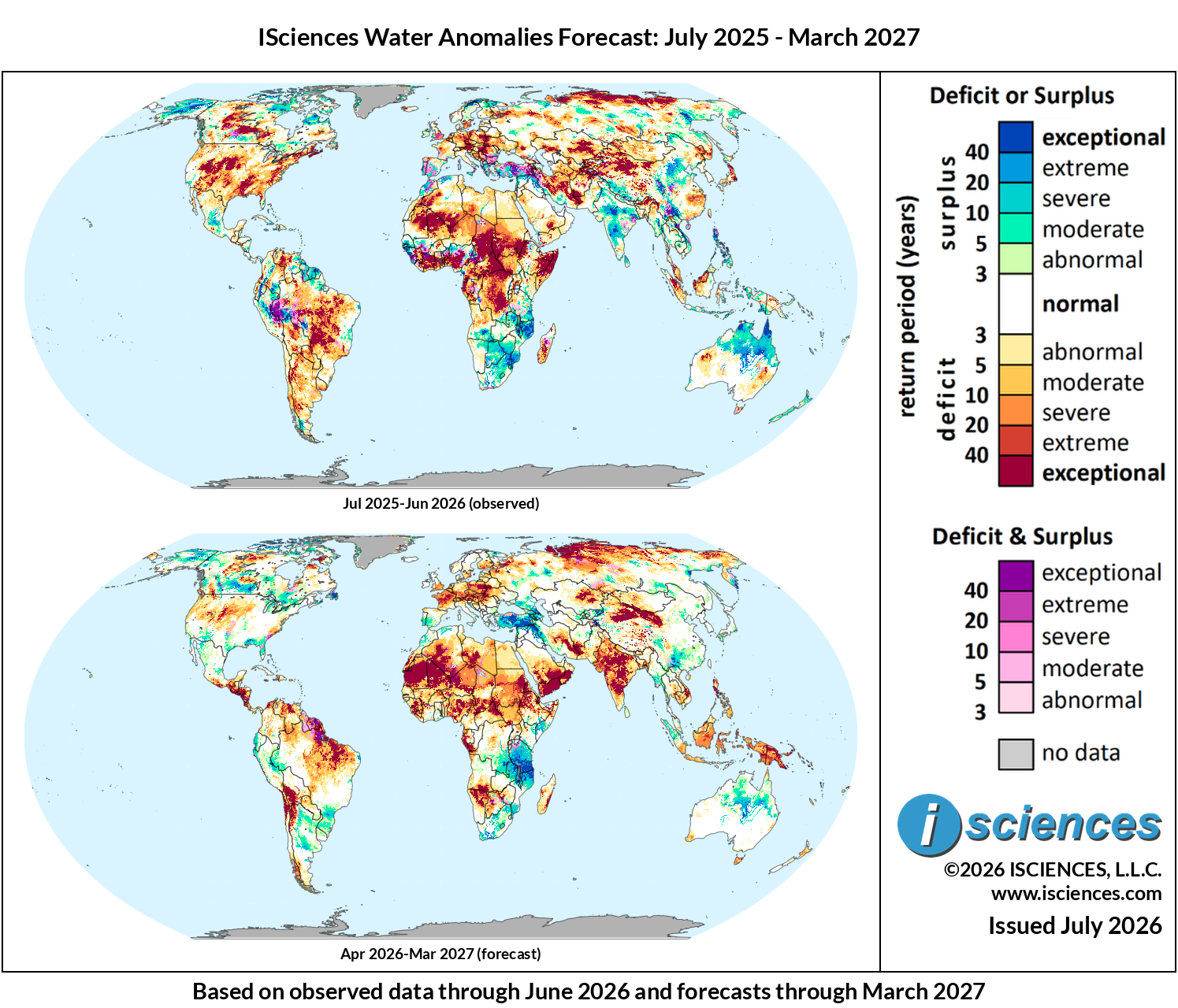
The in focus and regional synopsis sections that follow provide highlights of regional water forecasts. Detailed regional maps are available in the full report: ISciences Global Water Monitor & Forecast Watch List July 15, 2026 (pdf).
In Focus: Europe’s Dying Rivers and Deadly Heat; Future Flooding in Central Asia and the Middle East
The July 7 NOAA CFSv2 forecast ensemble shows Nino3.4 sea surface temperature anomalies currently at approximately 2°C above the 1991–2020 baseline and tracking toward an ensemble mean peak of 4.0°C in October through January 2026–27. This would substantially exceed the 1997–98 and 2015–16 benchmarks and rank as the strongest El Niño in the observational record.
Pacific sea surface temperatures have now crossed the threshold for El Niño, with the WMO placing the probability of El Niño conditions at 80% through the summer season — one of the strongest ENSO events on record. This month’s WSIM In Focus examines the emerging El Niño’s in two regions: a water emergency in Europe where high-pressure blocking is concentrating heat and drought into a historic emergency, and a dramatic drought-to-flood reversal across Central Asia and the Middle East.
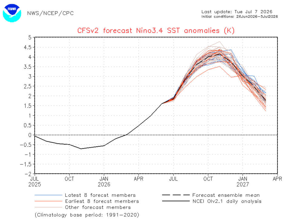
NOAA CFSv2 Nino3.4 SST anomaly forecast ensemble (°C relative to 1991–2020 climatology). Initial conditions: 26 Jun–5 Jul 2026. Blue lines: latest 8 ensemble members; orange lines: earliest 8 members; dashed black: ensemble mean; solid black: NCEI OIv2.1 daily analysis. Source: NOAA NWS/NCEP/CPC.
Europe: Drought, Heat, and Dying Rivers
In Poland, IMGW has issued 61 hydrological drought warnings covering approximately half the country, including the Vistula, Oder, Wisłoka, and Orzyc river basins recording flows below long-term minimums still rising. The Vistula (Warsaw’s primary water source) dropped to just 19 cm in July 2025, a fraction of its 230 cm seasonal norm and 2026 is tracking on a similar trajectory. The EU Drought Observatory placing Poland, Belarus, and Ukraine under formal alert status in June. The crisis extends beyond Poland’s borders. On the Rhine, vessels south of Duisburg are restricted to as little as 20% of cargo capacity as water levels at the Kaub chokepoint fall toward 40 cm — the threshold at which, according to commodity analysts tracking the corridor, “the Rhine’s role as a bulk freight corridor effectively suspends.” Freight rates on the Rotterdam–Mannheim corridor have risen 40–60% above normal. The disruption is compounded by the simultaneous closure of the right bank Rhine railway until mid-December 2026, eliminating the primary alternative for bulk cargo — a dual-mode failure that echoes the Rhine crisis of 2022. WSIM’s total blue water anomaly record for the Vistula at central Warsaw quantifies the depth of this crisis: the basin crashed to exceptional deficit during Apr-Jun 2025, recovered Oct 2026 – Feb 2027, then collapsed again to exceptional deficits by May 2026 — where it has remained through June. The forecast projects a gradual recovery toward near-normal conditions by late 2026.

WSIM V3 total blue water anomalies at the Vistula River, central Warsaw, Poland, January 2025–May 2027, expressed as return period.
In late June, a high-pressure omega block locked over central Europe and delivered a historic heat dome. France recorded its hottest national average temperature on record on June 24, and Germany broke 252 all-time station records in a single event, with Coschen reaching 41.7°C on June 28. Poland set a new national record days later with Słubice hitting 40.5°C. At least 1,000 excess deaths were recorded in France in a matter of days, overwhelmingly among those over 65. With at least 191 million Europeans forecast to face temperatures above 35°C, the WMO catalogued severe health impacts and mobilized early warning systems across the continent. A rapid attribution study by World Weather Attribution found the event would have been approximately 3.5°C cooler in 1976, and that such extremes are now “tens to hundreds of times more likely since only 2003 and virtually impossible just 50 years ago.” The extent and intensity of the heat wave is detailed in our WSIM temperature anomalies for Europe in June 2026. Traditionally, El Niño has complex effects across Europe; our WSIM seasonal forecast indicates that intense deficits will remain through September before beginning to lessen moving into 2027.
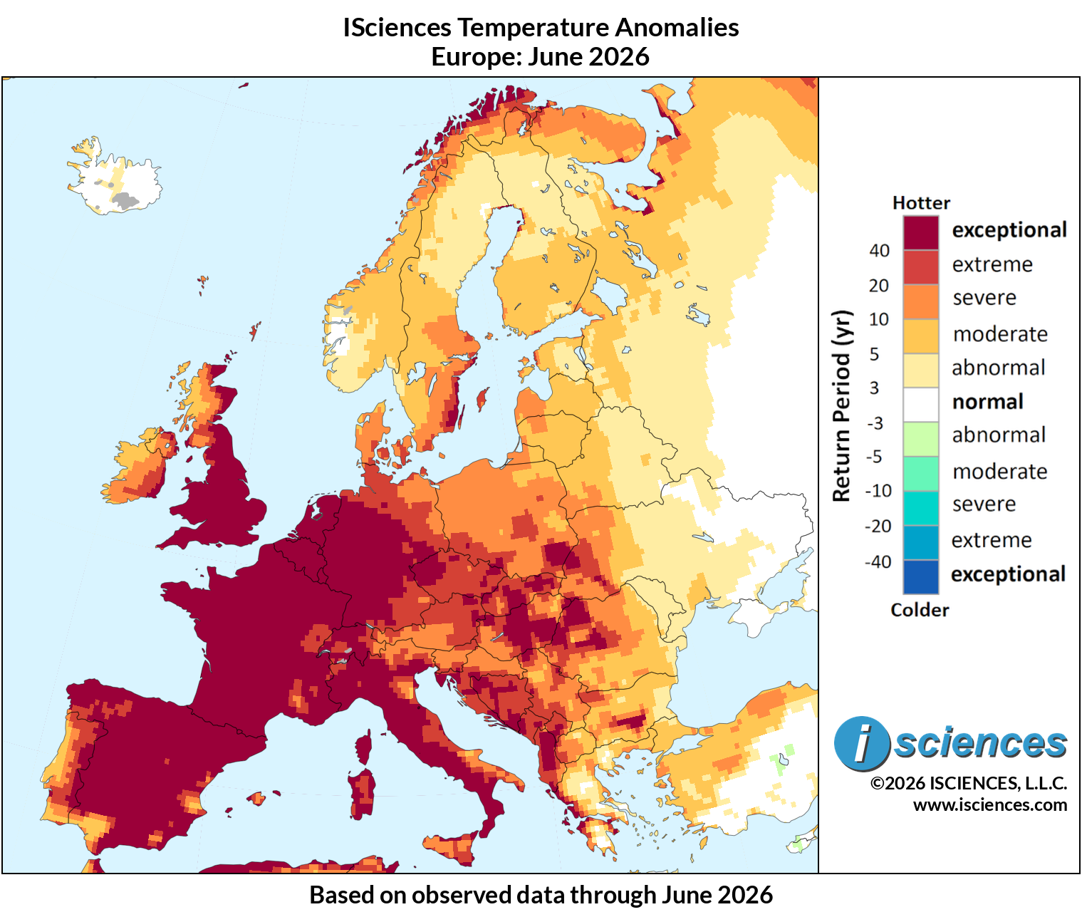
ISciences temperature anomaly return periods for Europe, June 2026.
Central Asia and the Middle East: El Niño Flooding Reversal
While El Niño is continuing a heatwave across Europe, extreme surpluses appear to be in line for the Middle East and Central Asia. The WMO warned in early June that “higher-than-average precipitation” was likely to accompany a developing event with 80% probability through the summer. In late June, Uzbekistan’s national meteorological agency Uzhydromet issued flash flood and mudslide warnings for nine of the country’s regions, including Kashkadarya, Surkhandarya, Samarkand, Fergana, and Andijan in the Fergana Valley for June 23–27. The warnings coincided with temperatures hitting 41–44°C in Uzbekistan’s southern desert zones. In Tajikistan, the Ministry of Transport warned of heavy rains, mudslides, and dust storms due to high temps and glacier melt across Sughd and Khatlon provinces, with the Panj, Vakhsh, Varzob, and Zeravshan rivers running high through early July. The transboundary flooding prompted a ministerial meeting in Bishkek in early July, where officials and scientists from Central Asia and The World Bank convened to coordinate early warning systems and data sharing.
A similar dynamic is playing out in the Middle East. A region that has endured a decade-long drought is now dealing with flood emergencies on rivers that were running critically low just months ago. In late May, heavy rainfall combined with massive upstream releases from Turkish reservoirs sent the Euphrates surging through Raqqa and Deir Ezzor provinces in Syria and into Iraq’s Anbar province. The Maadan bridge in Raqqa closed due to structural damage; an earthen bridge in Deir Ezzor was swept away. Syria’s Tabqa Dam opened spillways to relieve pressure, while Iraq’s Anbar Governor declared a 72-hour emergency alert with the river still rising. Approximately 2,400 families displaced in Deir Ezzor alone. Eastern Syria had seen groundwater decline by up to 60% over the prior decade, the Mosul Dam had been critically depleted, and Lake Urmia in Iran had effectively dried. Syria and Turkey coordinated Euphrates releases as conditions stabilized, but the atmospheric dynamics that drove the May flooding are expected to persist through summer. WSIM’s seasonal forecast suggests that the developing El Niño will continue to produce widespread surpluses throughout the Middle East and Central Asia well into 2027.
Sources:
WMO El Niño/La Niña Bulletin — June–August 2026. World Meteorological Organization, 2026.
Drought warnings cover half of Poland as river levels continue to fall. TVP World, July 6, 2026.
Vistula River Hits Historic Low as Drought Intensifies Across Poland. Warsaw Insider, July 8, 2025.
Precipitation, relative humidity, soil moisture and river flow for May 2026. Copernicus Climate Change Service, 2026.
Current Drought Situation in Europe. EU Joint Research Centre / European Drought Observatory, June 2026.
European heatwave linked to 1,000 excess deaths in France. Al Jazeera, June 28, 2026.
Records fall as extreme heat grips Europe. World Meteorological Organization, June 29, 2026.
Fossil fuel emissions have rapidly worsened European heatwaves in just a few decades. World Weather Attribution, June 26, 2026.
El Niño could bring unusually heavy summer rains to Central Asia, WMO warns. Times of Central Asia, June 4, 2026.
Uzhydromet issues flash flood warnings for mountainous areas across Uzbekistan. Kun.uz, June 22, 2026.
Tajikistan warns of mudslides as Central Asia expands flood cooperation. Times of Central Asia, July 2, 2026.
Flood alerts in Syria and Iraq after heavy rainfall and water releases by Turkey. The National, May 27, 2026.
Syria, Iraq were running out of water, now dams are flooding. Jerusalem Post, May 31, 2026.
Low water hampers Rhine river shipping in Germany, transport costs rise. Reuters, July 13, 2026.
Key European shipping corridor hit by river and rail freight ‘double whammy’. American Journal of Transportation, July 13, 2026.
Watch List: Regional Synopsis
United States: Observed long-term conditions (Jul 2025–Jun 2026) show severe to exceptional deficits across the majority of the region with the most severe areas in the Upper Colorado River Basin, Louisiana and the lower Mississippi, and an eastern corridor from Virginia north through New England. The seasonal forecasts (Apr 2026–Mar 2027) projects El Niño delivering substantial relief to the Gulf Coast and Southeast, with moderate to severe surpluses arriving across Louisiana, Mississippi, Alabama, Georgia, and the Carolinas by Oct–Dec 2026. Surpluses are expected to intensify westward to California and northeast to Maine moving into 2027.
Canada: Observed long-term conditions (Jul 2025–Jun 2026) show a dense core of exceptional deficits centered on central Saskatchewan and Alberta extending into Manitoba near Winnipeg, westward into northeast British Columbia, and northward into the Northwest Territories interior. Moderate to exceptional surpluses cover Nunavut and the high Arctic coast along Hudson Bay. The seasonal forecast (Apr 2026–Mar 2027) shows Prairie deficits transitioning to surpluses by Jul–Sep 2026, Northwest Territory deficits remaining through Mar 2027 and most of the country returning to normal to abnormal conditions by the end of the year.
Mexico, Central America, and the Caribbean: Observed long-term conditions (Jul 2025–Jun 2026) show moderate, with pockets of severe, deficits across northern Mexico in Sonora, Chihuahua, and Coahuila near Monterrey. Moderate to extreme surpluses were observed across central Mexico from Guadalajara to Mexico City, while a mix of surplus and deficit conditions were observed throughout Cuba, Jamaica, Haiti, and the Dominican Republic. The seasonal forecasts (Apr 2026–Mar 2027) projects El Niño will result in moderate surpluses throughout northern and central Mexico beginning Jul-Sep 2026, while moderate to severe deficits will intensify throughout southern Mexico, Central America, and the Caribbean starting in Jul 2026; potentially suppressing the important rainy season.
South America: Observed long-term conditions (Jul 2025–Jun 2026) show a band of exceptional surpluses across Peru, Ecuador, and western Colombia along with an additional area of moderate to exceptional surpluses throughout eastern Venezuela, Guyana, Suriname, and French Guiana. Mixed surplus and deficit conditions spanned the Mato Grosso and upper Amazon basin, while severe to exceptional deficits extended from the arc from northeastern Brazil near Fortaleza south through Paraguay and northern Argentina near Buenos Aires. The seasonal forecasts (Apr 2026–Mar 2027) project most of Brazil will transition to normal conditions by Oct-Dec 2026 before returning to mostly severe to exceptional deficits in early 2027. Moderate to exceptional surpluses are expected to emerge throughout southeastern Brazil, Paraguay, Uruguay, and Argentina during Oct-Dec 2026 and intensify during early 2027.
Europe: Observed long-term conditions (Jul 2025–Jun 2026) show exceptional deficits across a large contiguous block centered on Germany, Poland, Czech Republic, Austria, and Hungary — spanning from the Rhine River valley through Warsaw and south along the Danube to Budapest — with extreme deficits observed west through France near Paris and south into northern Italy’s Po Valley, and moderate to severe deficits reaching Denmark and the United Kingdom. Surpluses are confined to northern Scandinavia, the Iberian Peninsula, southern Balkans and Greece, and all of Turkey. The seasonal forecasts (Apr 2026–Mar 2027) offer limited near-term relief — exceptional to severe deficits across the Germany–Poland–Czech Republic corridor are expected to persist through at least Oct–Dec 2026, before much of the continent is expected to transition to a mix of normal to moderate surpluses by Jan-Mar 2027.
Africa: Observed long-term conditions (Jul 2025–Jun 2026) show a massive band of exceptional deficits from Senegal and Mauritania east across Mali, Burkina Faso, Niger, and Chad to Sudan-Ethiopia border region. A separate zone of exceptional deficits blanketed the Horn of Africa from Somalia through Djibouti and into eastern Ethiopia towards Addis Ababa. Conversely, severe to exceptional surpluses persist along the Zambezi River basin through Mozambique, Zambia, and Malawi and deeper into southern Africa. The seasonal forecasts (Apr 2026–Mar 2027) project El Niño amplifying the current Horn deficits while suppressing the Kiremt rainy season through Dec 2026 while simultaneously exacerbating surpluses and floods throughout Mozambique, Zambia, Tanzania, and Zimbabwe to the south. Exceptional deficits are forecast to emerge in southern Africa during early 2027.
Middle East: Observed long-term conditions (Jul 2025–Jun 2026) show a mix of severe to exceptional surplus and transitional conditions across the entirety of Turkey extending east into Iraq and western Iran. Mixed conditions transition to severe to exceptional deficits across central and eastern Iran. The seasonal forecasts (Apr 2026–Mar 2027) project that the emerging El Niño will deliver exceptional surpluses across the Turkey–Syria–Iraq-Iran northern crescent through Jan-Mar 2027. Despite surpluses in the northern corridor, exceptional deficits in the southern Arabian Peninsula will expand greatly during Oct-Dec 2026, and then recede to Yemen and Oman by Jan-Mar 2027.
Central Asia and Russia: Observed long-term conditions (Jul 2025–Jun 2026) show Russia with a broad band of exceptional deficits across northern Siberia and localized sections of the Volga-Ural region along with central-eastern Kazakhstan south into the Uzbekistan-Turkmenistan-Tajikistan-Kyrgyzstan border region. The seasonal forecasts (Apr 2026–Mar 2027) project a significant El Niño-driven transition for the Uzbekistan-Turkmenistan-Tajikistan-Kyrgyzstan region from exceptional deficits to exceptional surpluses beginning Oct–Dec 2026 and extending through Jan–Mar 2027. Russian deficits are expected to persist throughout the forecast but lessen in their extent.
South Asia: Observed long-term conditions (Jul 2025–Jun 2026) show exceptional surpluses covering a large contiguous area of central and peninsular India from Madhya Pradesh through Maharashtra and into Karnataka, Telangana, and Andhra Pradesh, extending east through Jharkhand and West Bengal toward Bangladesh near Dhaka. Pakistan’s Indus valley from Karachi north through Lahore also exhibited moderate to extreme surpluses. The seasonal forecasts (Apr 2026–Mar 2027) project a near-complete reversal as El Niño suppresses the Indian summer monsoon season. Moderate deficits will engulf the entire region starting Jul-Sep 2026. Extreme to exceptional deficits will emerge along the northern border of India and begin to intensify starting Oct-Dec 2026; first along the Indus River Basin and greater Pakistan-India border region, and then in north-central India and moving south along the western coast in Jan-Mar 2027.
Southeast Asia and the Pacific: Observed long-term conditions (Jul 2025–Jun 2026) show moderate to exceptional surpluses across much of the mainland including central Myanmar, western Thailand, Laos, and northern Vietnam. Exceptional surpluses also covered the Philippines and Indonesian South Papua. Moderate to severe deficits were observed across Indonesia’s Sumatra, Kalimantan, and Java. The seasonal forecasts (Apr 2026–Mar 2027) are dominated by severe to exceptional deficits across Indonesia and Papua New Guinea as El Niño suppresses the monsoon season starting Jul–Sep 2026 and continuing through Oct-Dec 2026 before transition to a mix of moderate surpluses across Indonesia and moderate to severe deficits in the Philippines in Jan-Mar 2027.
East Asia: Observed long-term conditions (Jul 2025–Jun 2026) show exceptional deficits concentrated across a large contiguous block in western China (Xinjiang and Qinghai) and extending into Mongolia. Exceptional to extreme deficits were also observed around and south of Shanghai, northeast China, and most of Japan. The seasonal forecasts (Apr 2026–Mar 2027) project El Niño shifting China’s water balance: the southeast coast will transition from deficits to moderate surpluses beginning during Jul-Sep 2026 and intensifying during Oct-Dec 2026. Deficits in northwest China will reduce in size and intensity starting Jul-Sep 2026 with moderate to severe surpluses emerging along the Kazakhstan border region from Oct 2026 through Mar 2027.
Australia & New Zealand: Observed long-term conditions (Jul 2025–Jun 2026) show exceptional surpluses across the Northern Territory and northern Queensland, with severe to extreme surpluses extending south through the Lake Eyre basin. Moderate to extreme deficits were observed in inland Western Australia east of Shark Bay, inland west of Brisbane, and Tasmania. Seasonal forecasts (Apr 2026–Mar 2027) show the northern Australia surplus persisting through Oct-Dec 2026, however, they are expected to reduce in intensity and recede from the northern coastline. The southern half of Australia is forecast to be under mostly normal conditions through Mar 2027. Moderate to severe deficits may emerge in Tasmania and northern New Zealand Oct-Dec 2026.