
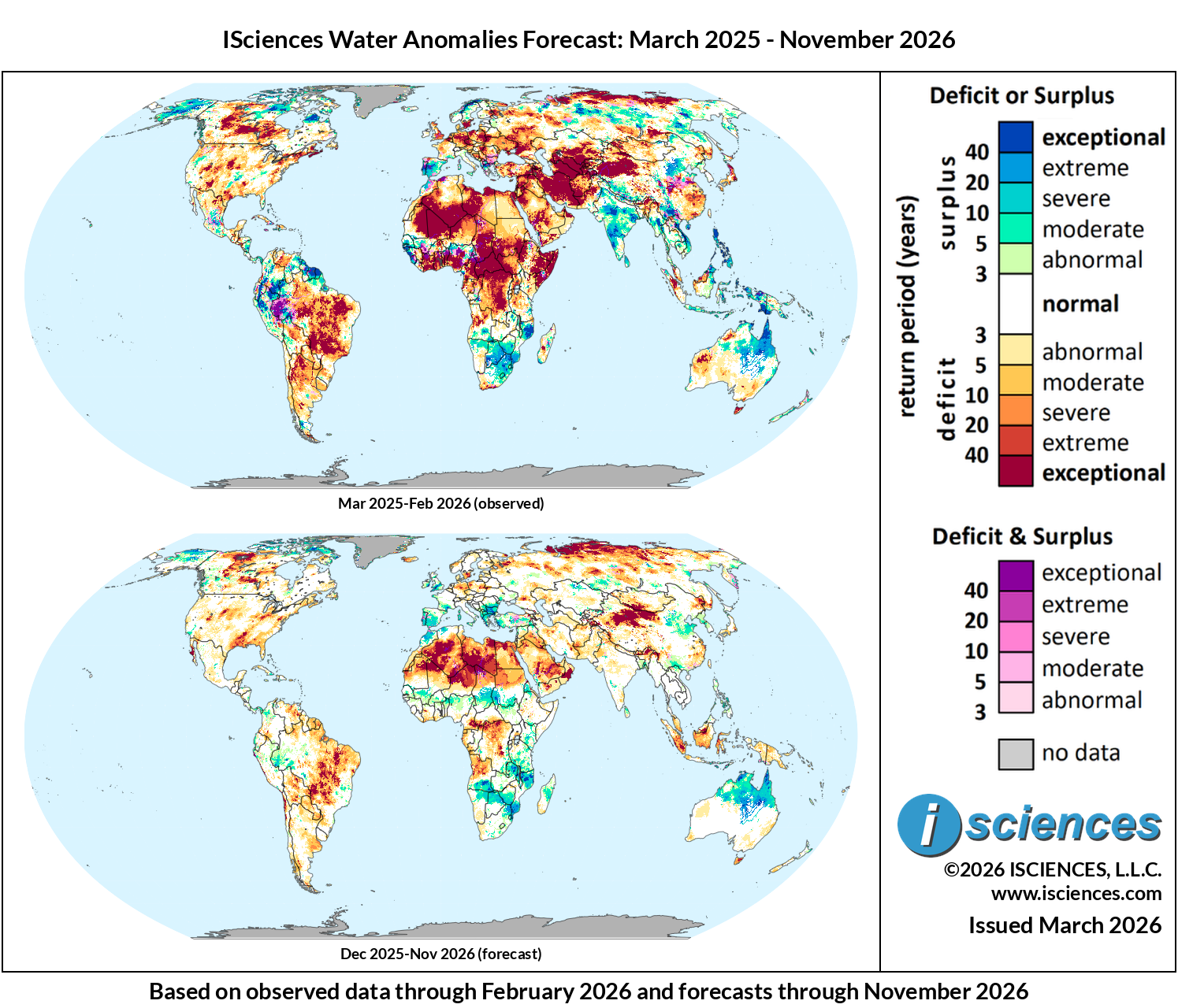
These maps present regions currently experiencing long-term (12 month) anomalies using observed temperature and precipitation data from March 2025 through February 2026 (top) and regions likely to encounter significant water anomalies during the one-year period beginning in December 2025 and running through November 2026 using 3 months of observed data and 9 months of forecast data (bottom).
The synopsis that follows provides highlights of regional water forecasts. Regional details are available in ISciences Global Water Monitor & Forecast Watch List March 12, 2026 (pdf).
This synopsis provides highlights of regional water forecasts. More detailed analysis is available in “Watch List: Regional Details” immediately following the synopsis.
United States: Observed long-term conditions (Mar 2025–Feb 2026) show widespread severe to exceptional deficits across New England, the Mid-Atlantic, southern Texas, the central plains, and the southwest. The most intense deficit conditions include Maine, New Hampshire, and Vermont, west to the regions surrounding Buffalo, NY and Erie, PA, and south along the West Virginia-Virginia border. Southern deficits are concentrated in southern Arkansas, Texas through the Houston, Austin, San Antonio corridor, and then along the central Arizona-New Mexico border. Remaining intense deficits were observed southwest of the Great Salt Lake and the Nebraska-Colorado-Wyoming border zone. Exceptional surpluses persist in western and northern Alaska. Recent seasonal conditions (Dec 2025–Feb 2026) show exceptional deficits throughout much of the eastern half of the country from the central plains to New England, and severe to exceptional surpluses emerging in the Pacific Northwest and along the California-Nevada border. The seasonal forecasts show broad improvement across the eastern states, with deficits expected to diminish to moderate-abnormal levels by Jun–Aug 2026 and near-normal conditions returning to most of the country by fall. However, moderate to severe long-term deficits are forecast to persist in eastern Texas, southern Arkansas, Louisiana, south of the Great Salt Lake, central Wyoming, central Indiana, and northwest Ohio.
Canada: Observed long-term conditions (Mar 2025–Feb 2026) show exceptional deficits across western Canada. The most intense conditions track from the Great Bear Lake region, south into the British Columbia-Northwest Territories-Alberta border, then moving further south and east into central Saskatchewan and northern Manitoba before terminating in western Ontario. Severe to exceptional deficits were also observed throughout Nova Scotia, New Brunswick, Prince Edward Island, and Newfoundland. In contrast, northern Quebec and coastal Labrador show exceptional surpluses. Recent seasonal conditions (Dec 2025–Feb 2026) are broadly consistent with the long-term pattern. The forecasts indicate gradual Prairie improvement, with deficits moderating in their geographic extent by Mar–May 2026 and continuing to diminish through summer. However, deficits are expected to intensify in the Great Bear Lake region. Atlantic province deficits are expected to ease, with most of the country approaching near-normal conditions by Sep–Nov 2026.
Mexico, Central America, and the Caribbean: Observed long-term conditions (Mar 2025–Feb 2026) show moderate to exceptional deficits across northern Mexico, with the most intense deficits within Coahuila. Central Mexico around Guadalajara and Mexico City displays mixed deficit and surplus conditions. Eastern Chiapas, Guatemala, and Honduras show localized pockets of extreme-exceptional deficits, while Nicaragua, Costa Rica, and Panama displayed moderate surpluses. Western Cuba shows moderate to severe deficits with more mixed conditions across Hispaniola. Recent seasonal conditions (Dec 2025–Feb 2026) are broadly consistent in northern Mexico, but Central America — particularly Guatemala, Belize, Honduras, and El Salvador — saw significant surplus intensification. The seasonal forecasts indicate gradual improvement in northern Mexico, with deficits moderating through spring 2026. Central American surpluses are expected to ease toward near-normal by mid-2026, and most of the region will approach normal conditions by Sep–Nov 2026.
South America: Observed long-term conditions (Mar 2025–Feb 2026) show exceptional deficits dominating a vast area of central and eastern Brazil, spanning the Amazon basin through Pará and Amazonas, extending south through Mato Grosso, Goiás, and Minas Gerais into the São Paulo region. Deficits extend further into Paraguay along the Paraná River and into northern Argentina through the Chaco. Western Amazonia in Acre and Rondônia exhibits exceptional mixed deficit and surplus conditions. In contrast, exceptional surpluses stretch across Colombia and Venezuela along the Orinoco basin and into Guyana and Suriname, with additional surplus conditions along the Andean corridor through Peru and Ecuador. Recent seasonal conditions (Dec 2025–Feb 2026) are broadly consistent with the long-term pattern. However, the surplus and deficit conditions are less intense and widespread. The seasonal forecasts indicate Brazilian and Bolivian deficits will gradually diminish from exceptional to severe-moderate levels by mid-2026, though widespread deficits are expected to persist across central Brazil. Northern surpluses in Colombia will moderate through spring before returning to near-normal. Severe to extreme deficits are expected to emerge in Venezuela by Sep–Nov 2026.
Europe: Observed long-term conditions (Mar 2025–Feb 2026) show moderate to exceptional deficits across much of eastern and central Europe, with intense conditions in the Ukraine-Belarus-Poland border zone, the Romanian-Hungarian corridor, Germany along the Elbe, and eastern Turkey. Severe to extreme deficits were also observed in the United Kingdom, concentrated in eastern and central England. In contrast, moderate to exceptional surpluses persist across the Iberian Peninsula, northwest Scandinavia, and Greece and the surrounding areas. Recent seasonal conditions (Dec 2025–Feb 2026) show improvement across western and central Europe, but exceptional surpluses intensified in Greece expanding across the southern Balkans. The seasonal forecasts indicate broad improvement with most of the continent returning to near-normal by spring 2026, however, deficits are expected to remain in the Ukraine-Belarus-Poland and Germany-Poland border zones. Deficits may also emerge along the Norwegian coast and persist in the Ukraine-Poland border zone into summer 2026.
Africa: Observed long-term conditions (Mar 2025–Feb 2026) show severe to exceptional deficits along the West African coast from Sierra Leone through Liberia, Côte d’Ivoire, Ghana, and Nigeria into Cameroon. Exceptional deficits extend across the Central African Republic and throughout much of the Democratic Republic of the Congo (DRC) along the Congo River basin. The Horn of Africa — Eritrea, Djibouti, Ethiopia, and Somalia — also experienced severe to exceptional deficits. North Africa including Morocco, Mali, Mauritania, Algeria, Libya, and Egypt along the Nile shows moderate to exceptional deficits. In contrast, a band of surpluses runs through the Sahel from Senegal through southern Mali and Burkina Faso and into Niger and Chad. Moderate to exceptional surpluses were also present across northern South Africa, Zimbabwe, Zambia, and Mozambique east of Lake Malawi. Recent seasonal conditions (Dec 2025–Feb 2026) broadly align with the long-term pattern, with exceptional surpluses and mixed conditions emerging in western Ethiopia along with deficits mitigating in the northwest. Seasonal forecasts indicate West African coastal deficits will moderate through mid-2026, and DRC deficits will reduce in extent. Sahel surpluses are expected to expand and persist, while southern African surplus conditions are forecast to continue through the remainder of the period while expanding north of Lake Malawi into Tanzania and Kenya.
Middle East: Observed long-term conditions (Mar 2025–Feb 2026) show exceptional deficits across virtually the entirety of Iran, with severe to exceptional deficits extending west through Iraq along the Euphrates and Tigris basins into Syria and southeastern Turkey. Lebanon, Jordan, and Israel show severe to exceptional deficits. Saudi Arabia experienced moderate to severe deficits across most of the country with exceptional conditions around Mecca and Riyadh extending east toward Kuwait. Oman and the UAE display moderate to exceptional deficits from Muscat to Dubai and Abu Dhabi. Recent seasonal conditions (Dec 2025–Feb 2026) show notable relief across the entirety of the region with the exception of extreme to exceptional deficits in northwest Saudi Arabia near Jordan. Surpluses have also emerged in eastern Turkey and northern Iraq. The seasonal forecasts indicate significant improvement across much of the northern region through spring 2026, with Iran and Iraq transitioning to moderate-abnormal deficit levels. The Arabian Peninsula is expected to retain moderate to exceptional deficits through the remainder of the period with the most intense deficits persisting around and east of Mecca. Exceptional deficits are expected to emerge in eastern Iran during Sep-Nov 2026.
Central Asia and Russia: Observed long-term conditions (Mar 2025–Feb 2026) show exceptional deficits across all Central Asia — Kazakhstan, Uzbekistan, Turkmenistan, Tajikistan, and Kyrgyzstan — with the most intense conditions concentrated around the Aral Sea basin moving southwest towards the Caspian Sea, and along the Amu Darya and Syr Darya river systems. Western Russia experienced moderate to exceptional deficits. In contrast, Russia’s Far East and parts of northern Siberia displayed moderate to exceptional surpluses. Recent seasonal conditions (Dec 2025–Feb 2026) are broadly consistent across Central Asia, though surpluses are emerging in the Altai Republic and along the western Siberian plain and intense deficits from Kazakhstan towards the Caspian Sea have mostly dissipated. The seasonal forecasts indicate gradual improvement across Kazakhstan and much of the greater region, with deficits moderating by mid-2026. However, severe to exceptional deficits are expected to emerge in March along Russia’s northern coast near the Kara Sea and persist through Nov 2026.
South Asia: Observed long-term conditions (Mar 2025–Feb 2026) show widespread exceptional surpluses across much of India, with the most intense conditions in central India through Madhya Pradesh and Maharashtra, southern India across Karnataka and Andhra Pradesh. Severe to exceptional deficits were observed throughout northeast India. Eastern Pakistan along the Indus valley displays moderate surpluses, and Sri Lanka and Nepal also exhibited surplus conditions. In contrast, western Pakistan and Afghanistan show severe to exceptional deficits. Recent seasonal conditions (Dec 2025–Feb 2026) broadly align with the Indian surplus pattern across peninsular and central India but have reduced in intensity. The seasonal forecasts indicate Indian surpluses will persist through Mar–May 2026 before diminishing toward near-normal. Exceptional deficits are expected to persist in northeastern India and Bangladesh through Mar-May 2026. Western Pakistan and Afghanistan deficits are expected to moderate through mid-2026 before re-emerging in Sep-Nov 2026.
Southeast Asia and the Pacific: Observed long-term conditions (Mar 2025–Feb 2026) show moderate to exceptional surpluses across the Philippines, most of Indonesian Papua, and southern New Guinea along the Indonesian-Papua New Guinea border. Northern Sumatra and Malaysian Borneo experienced severe to exceptional deficits, while Mainland Southeast Asia displayed mostly surplus conditions--with the most intense areas along the Vietnam-Laos border and central-eastern Myanmar. Recent seasonal conditions (Dec 2025–Feb 2026) broadly reflect the long-term pattern. However, deficits have expanded throughout Borneo, Sulawesi, and New Guinea. The seasonal forecasts indicate Philippine surpluses will diminish toward near-normal by mid-2026. Sumatra and Borneo deficits are expected to persist through Mar-May 2026 and then diminish to near normal at the end of the forecast period.
East Asia: Observed long-term conditions (Mar 2025–Feb 2026) are dominated by severe to exceptional deficits across western Mongolia, extending into northwestern China through Xinjiang and Inner Mongolia. Moderate to extreme deficits also dominate the southeast regions of China west and south of Shanghai. In contrast, moderate to exceptional surpluses were observed in the provinces surrounding Beijing, the southern provinces of Yunnan and Guangxi, and along the Tibetan Himalayan ridge. Most of Japan was under moderate to exceptional deficits, while the Korean Peninsula was largely near-normal. Recent seasonal conditions (Dec 2025–Feb 2026) broadly reflect the 12-month pattern. However, recent surpluses surrounding Beijing have expanded south and westward along the Yellow River and into Chongqing. The seasonal forecasts indicate deficits in southeast and northwest China will reduce in intensity and extent, while surpluses west of Beijing and in the southern provinces will reduce to abnormal-moderate levels. Most of the region is expected to return to mixed normal to moderate conditions by Jun-Aug 2026.
Australia & New Zealand: Observed long-term conditions (Mar 2025–Feb 2026) show moderate to exceptional surpluses across northern Australia, spanning the Northern Territory and Queensland. Southeastern Australia, particularly Victoria, southern New South Wales, and Tasmania, shows moderate to exceptional deficits. Widespread severe to exceptional deficits were also observed in Western Australia near Shark’s Bay and heading inland. New Zealand displays moderate surpluses across parts of both islands. Recent seasonal conditions (Dec 2025–Feb 2026) illustrate continued heavy surpluses across the northern regions but fading deficits in the south and western territories. The seasonal forecasts indicate northern surpluses will remain but lessen in intensity to mostly moderate-severe levels. Most southern and western deficits are expected to rapidly return to near normal conditions by Jun 2026.