
These maps present regions currently experiencing long-term (12 month) anomalies using observed temperature and precipitation data from August 2025 through July 2026 (top) and regions likely to encounter significant water anomalies during the one-year period beginning in May 2026 and running through April 2027 using 3 months of observed data and 9 months of forecast data (bottom).
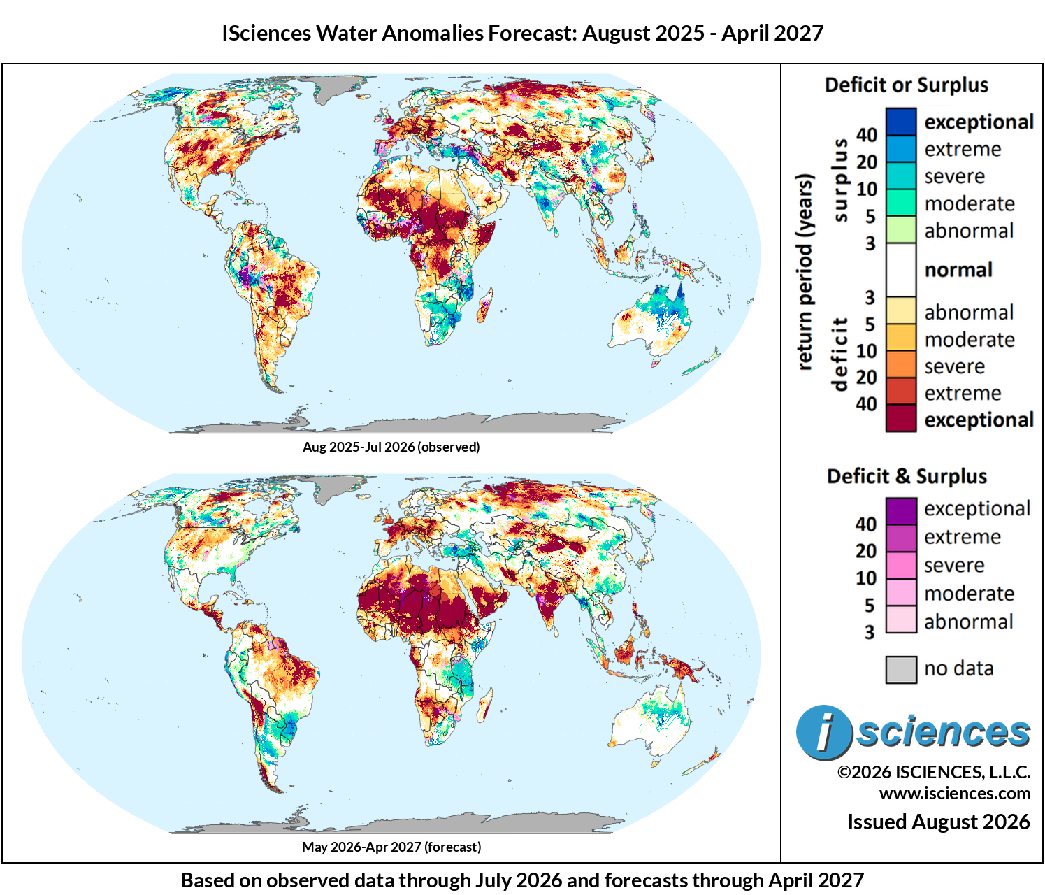
Figure 1: Worldwide water anomaly. Top: 12-month observed, Aug 2025–Jul 2026. Bottom: 12-month forecast, May 2026–Apr 2027
The in focus and regional synopsis sections that follow provide highlights of regional water forecasts. Detailed regional maps are available in the full report: ISciences Global Water Monitor & Forecast Watch List August 12, 2026 (pdf).
In Focus: An Exceptional El Niño, Flash Floods in Texas, and Europe’s Energy Emergency
Last month’s report documented the NOAA CFSv2 ensemble tracking toward a peak Nino3.4 anomaly of 4.0 °C, which would substantially exceed the 1997-98 and 2015-16 benchmarks. El Niño forecasts continue to increase overall probability and magnitude. At an August 4 Berkeley Earth press briefing, climate scientist Zeke Hausfather presented projections from 14 climate models showing the median peak now sits approximately 0.8 °C above the 2015-16 record, calling it “truly, a mind-blowing margin.” NOAA now places a four-in-five probability on a “very strong” event by year-end and regards El Niño conditions as near-certain through at least April 2027.
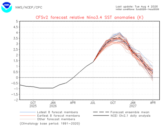
Figure 2: NOAA CFSv2 Nino3.4 SST anomaly forecast ensemble (°C relative to 1991-2020 climatology). Source: NOAA NWS/NCEP/CPC.
NOAA ENSO team lead Michelle L’Heureux cited “very vigorous atmosphere-ocean coupling across the equatorial Pacific Ocean” as driving the growing confidence (Figure 2, Figure 3). If the projections hold, global average temperatures in 2027 could reach 1.7 °C above the pre-industrial baseline, approaching the 1.5 °C threshold governments pledged to avoid under the Paris Agreement. Justin Mankin at Dartmouth College estimates the event could generate $10 trillion in economic losses by 2032.
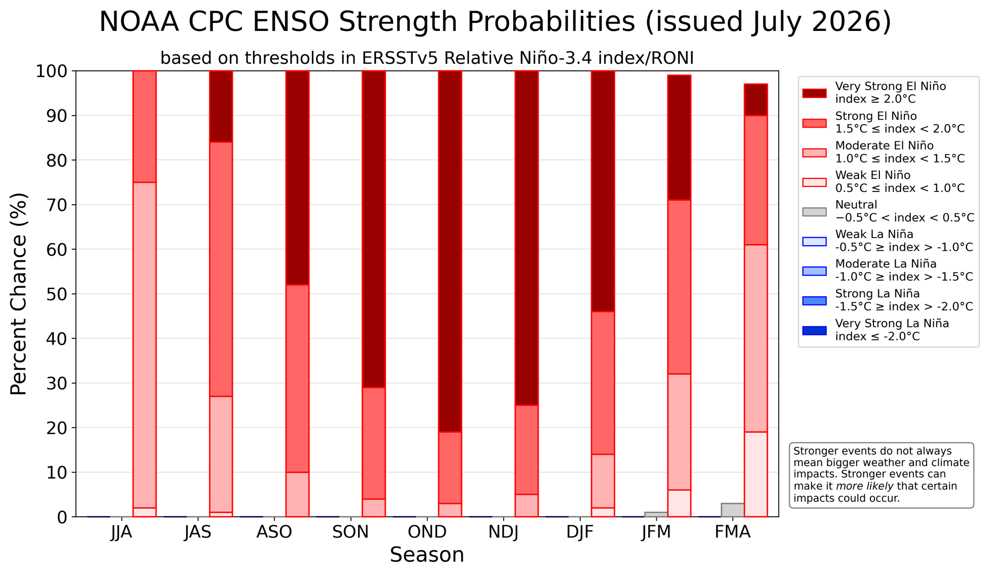
Figure 3: NOAA CPC ENSO event strength probabilities, current outlook (June 2026). Probability distribution across weak, moderate, strong, and very strong El Niño categories. Source: NOAA NWS/NCEP/CPC.
Texas: Flash Flood Alley, Two Years Running
The Texas Hill Country, a region of thin limestone soils and abrupt terrain that geologists call “Flash Flood Alley,” was struck by a second consecutive July disaster on July 16. Northern Uvalde County received up to 28 inches of rain over three days. The Guadalupe River at Comfort rose more than 30 feet in under three hours, cresting near 37 feet, and the Pedernales reached approximately 34 feet at Fredericksburg. Some 125 roadways were affected, 87 closed, and roughly 700 structures were damaged. Two people were killed.
The driving forces are a permanent feature of the geography: warm, moist Gulf air forced upslope against the Hill Country terrain generates extreme short-duration rainfall. Meteorologist Marshall Shepherd described the compounding factors: a warmer atmosphere holds more moisture, and the developing El Niño loads the Gulf-to-continent moisture pipeline that feeds these events. WSIM’s precipitation anomaly record for Comfort (Figure 4) documents both July 2025 and July 2026 as distinct extreme-surplus spikes — separated by a winter deficit period — confirming the back-to-back character of the flooding.
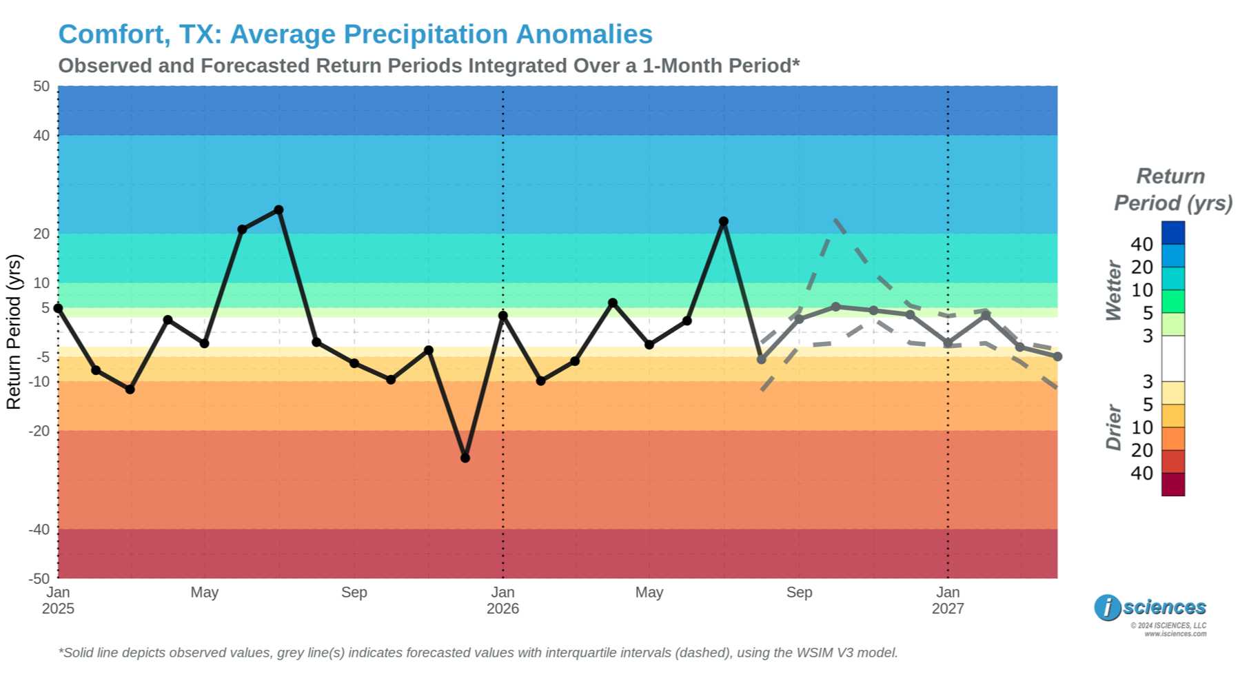
Figure 4: WSIM V3 average precipitation anomaly time series for Comfort, TX (return period, years). Observed values (solid black line) through July 2026 show two extreme-surplus peaks corresponding to the July 2025 and July 2026 Hill Country flood events. Source: ISciences WSIM V3.
The newly activated early warning system appears to have prevented a far higher death toll. Texas Tribune analysis found that earlier evacuations, improved alert infrastructure, and the daytime onset of flooding collectively saved lives that the 2025 event could not. What makes that result notable is how recently the system came together: just two weeks before the flood, KUT reported that Kerr County’s activation plan for its new sirens was still “a work in progress.” When the flood struck, three of six newly installed sirens were activated, Comfort’s volunteer fire department added two more, and private “River Sentry” towers at camps and RV parks along the Guadalupe provided advance notice to vulnerable communities. KSAT reported that the 2025 siren-funding legislation championed by Senator Bettencourt came through just in time.
Europe: Rivers, Reactors, and the Food Supply
The drought and heat emergency we’ve been detailing in Europe since June continued to intensify through July and into August. The Czech Republic recorded its highest overnight temperature ever – 27.9 °C – on August 4, and Italy’s Health Ministry placed 25 of 27 major cities on red alert, with all Italian cities elevated to red alert by Thursday. Wildfires broke out across Greece, where more than 500 firefighters battled an ongoing blaze in Western Attica near Athens; two helicopter crew members were killed when their aircraft collided in midair fighting the fire. With a second heat dome forecast to develop over the UK and western Europe beginning August 9, temperatures running 15-20 degrees F above seasonal averages in major western cities before spreading eastward, and above-average conditions projected across nearly the entire continent for the full month, the drought accompanying this heat has cascaded from a river-level story into a continent-wide energy emergency.
The Danube, flowing through ten countries from the German interior to the Black Sea, has receded to never-before-seen lows along much of its course. Budapest’s national water authority measured the river at 23 centimeters on July 30, well below the previous all-time record of 33 centimeters set in 2018. Romania’s Danube averaged just 1,630 cubic meters per second, approximately one-third of a typical July level. With no significant rain in the forecast and temperatures expected to exceed 38 °C across the region, the river continued to fall. WSIM’s total blue water anomaly record for the Danube at Vidin (Figure 5) illustrates the depth of the current situation with 3 consecutive months of at least 50-year return period deficits.
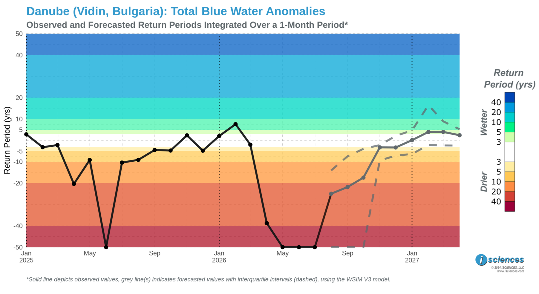
Figure 5: WSIM V3 total blue water anomaly time series for the Danube at Vidin, Bulgaria (return period, years). Source: ISciences WSIM V3.
The impacts of drought have cascaded rapidly into energy infrastructure across the continent. Hungary’s Paks nuclear plant, which supplies nearly half of the country’s electricity, progressively cut output as Danube cooling water levels dropped. Unlike most European nuclear facilities, Paks has no cooling towers, and draws directly from the Danube, which has historically been considered too substantial to experience drought conditions of this magnitude. On the night of August 4-5, it came within millimeters of complete shutdown. Flow through Budapest had fallen to 723 cubic meters per second, down from over 1,000 cubic meters per second in mid-July, and at 1:30 a.m. the last remaining turbine was still running only because the river had not dropped the final critical increment. By morning, flow had recovered fractionally to just shy of 750 cubic meters per second. Prime Minister Magyar stated that “Around half past one at night we were just a few millimetres away from a complete shutdown of Paks Nuclear Power Plant, but then the water level stopped dropping.” The crisis did not end with the near-miss. By August 5, three of Paks’s four reactors were offline, with the remaining unit at roughly 50% capacity; Magyar visited the site and warned of “a few critical days left.” Hungary nearly doubled electricity imports from neighboring nations and ordered over 300 Budapest buildings to extinguish lights, including Buda Castle and the Chain Bridge. A simultaneous malfunction at Hungary’s largest gas-fired plant in Százhalombatta compounded the grid shortage. Romania’s Cernavodă plant shut two reactors and, in a measure that illustrated the severity of the situation, authorities conducted a controlled explosion in the Danube to redirect flow toward the plant’s remaining cooling intake. The European Commission began preparations for an emergency Electricity Coordination Group meeting with the region’s most affected member states.
The nuclear energy disruptions sit within a broader European energy crisis driven by low rivers. July 2026 hydropower output ran at just 51% of normal in Austria, 48% in Switzerland, 63% in Germany, and 68% in France, a sector that in a normal year accounts for 28% of EU electricity. To the north, critically low water levels in the Vistula forced Poland to shut down the Kozienice and Połaniec coal-fired power plants, removing approximately 1.3 GW of capacity from the country’s power grid. This is the same river system documented in last month’s report as experiencing exceptional deficit conditions. On the Rhine, cargo vessels have been restricted to roughly 20% of normal capacity as water levels at the Kaub chokepoint approach the threshold at which bulk freight effectively suspends. The disruption is compounded by the ongoing closure of the right bank Rhine railway through mid-December 2026, eliminating the primary overland alternative at the same time. The recession of the Danube has also exposed the riverbed in striking fashion: a WWII bomb emerged at the base of Budapest’s Margaret Bridge, forcing its closure; a Viking cruise ship ran aground near Vidin with 186 passengers who ran out of food and water before rescue; and the bones of a woolly mammoth surfaced on a Bulgarian riverbed near Ryahovo (Figure 5).
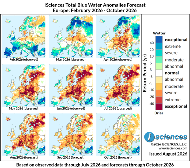
Figure 6: ISciences Total Blue Water Anomalies for Europe, February–October 2026 (1-month panels). Source: ISciences WSIM V3.
The drought’s reach extends to Western Europe (Figure 6). England received just 5.6 mm of rainfall through July 30, representing 8% of its long-term July average and less than half the previous record low of 13.4 mm set in 1911. A drought has been declared across half of England and all of Wales. NFU president Tom Bradshaw described oats as “very, very poor,” wheat at half its usual height, and warned that food shortages of some products appear likely. Dairy farmers reported declining milk yields as heat suppressed feed intake. Bradshaw: “Water security is a critical part of our food security and food security is our national security.” WSIM’s seasonal forecast suggests that the developing El Niño will sustain significant deficits across Europe through autumn, with only a gradual easing expected moving into 2027.
Watch List: Regional Synopsis
United States: Observed long-term conditions (Aug 2025–Jul 2026) show severe to exceptional deficits across much of the contiguous United States. The most intense deficits span nearly the entirety of the central plains, the lower Mississippi river basin, and the northeast from South Carolina heading north all the way to Maine. Conversely, Alaska recorded moderate to exceptional surpluses throughout most of the state. The seasonal forecasts (Aug 2026–Apr 2027) project El Niño delivering substantial relief and then surpluses to the Southeast, mid-Atlantic, and West Coast starting November and intensifying northward by year-end.
Canada: Observed long-term conditions (Aug 2025–Jul 2026) show a dense core of exceptional deficits centered on Alberta and Saskatchewan extending east into Manitoba near Winnipeg and west into the British Columbia interior; conditions that fueled severe wildfire activity across the Prairies through spring 2026. Recent observations capture a transition to surplus conditions beginning to displace the long-term Prairie drought and bring moisture relief to fire-stressed landscapes. The seasonal forecasts (Aug 2026–Apr 2027) project this transition to continue, with Alberta and Saskatchewan moving toward near-normal to moderate surplus through late 2026 while Ontario, Quebec, and the Maritimes also trend toward improved conditions and then surpluses.
Mexico, Central America, and the Caribbean: Observed long-term conditions (Aug 2025–Jul 2026) show moderate to severe deficits across northern Mexico from Sonora and Chihuahua east through Coahuila near Monterrey, while central Mexico from the Jalisco highlands east toward Mexico City recorded substantial surpluses. Severe to exceptional deficits covered the western coasts of Guatemala, El Salvador, Nicaragua, and Honduras. The seasonal forecasts (Aug 2026–Apr 2027) project El Niño suppressing rainfall across southern Mexico, Central America, and the Caribbean beginning Aug–Oct 2026, with exceptional to extreme deficits expected to persist through the forecast period, while northern Mexico transitions toward normal conditions by late 2026.
South America: Observed long-term conditions (Aug 2025–Jul 2026) show a complex pattern with exceptional mixed deficit-and-surplus anomalies across the western Amazon basin in western Brazil and Peru. Exceptional deficits across northeastern Brazil near Fortaleza, and moderate to severe deficits extending south through Paraguay and into northern Argentina near Buenos Aires. Severe to exceptional surpluses lined the northern coast from Venezuela through Guyana and the Pacific coast of Ecuador. The seasonal forecasts (Aug 2026–Apr 2027) project El Niño driving extreme to exceptional surpluses across Argentina, Uruguay, Paraguay, and southern Brazil from Aug–Oct 2026 onward. However, drought is projected to persist and intensify in northeastern Brazil’s through April 2027.
Europe: Observed long-term conditions (Aug 2025–Jul 2026) show exceptional deficits blanketing nearly all of Europe, with the most intense conditions forming an unbroken core across France, Germany, the United Kingdom, Poland, the Czech Republic, Austria, and Hungary extending south into northern Italy’s Po Valley. The Iberian Peninsula recorded mixed surplus-and-deficit conditions across much of Spain, while Portugal showed moderate deficits, offering only a partial break from the broader continental drought. The seasonal forecasts (Aug 2026–Apr 2027) offer little near-term relief, with severe to exceptional deficits projected to persist across western and central Europe through January 2027. However, the entire continent is expected to transition to a mix of normal to moderate surplus conditions by Feb-Apr 2027.
Africa: Observed long-term conditions (Aug 2025–Jul 2026) show exceptional deficits across two major corridors: a broad Sahel band stretching from Senegal and Mali east through Niger, Chad, and Sudan, and a separate zone covering the Horn of Africa from Somalia through eastern Ethiopia and Eritrea. Severe to exceptional surpluses were observed in the Great Lakes region in Kenya, Tanzania, and Uganda, and across the Zambezi basin through Zambia, Malawi, and Mozambique. The seasonal forecasts (Aug 2026–Apr 2027) project El Niño sustaining central African defictis and East African Rift through Oct 2026, but existing patterns of surplus and deficits are expected to moderate slightly heading into 2027.
Middle East: Observed long-term conditions (Aug 2025–Jul 2026) show a large divide, with exceptional surpluses covering Turkey and extending along the Tigris-Euphrates corridor through northern Syria and Iraq, contrasting with severe to large scale exceptional deficits across Iran into the Iran-Pakistan-Afghanistan border region. Recent conditions (May-Jul 2026) in the southern Arabian Peninsula from Yemen and Oman north through Saudi Arabia show large areas of exceptional deficits have developed. The seasonal forecasts (Aug 2026–Apr 2027) project El Niño strengthening surpluses across the Turkey-Syria-Iraq northern crescent through the forecast period, while mitigating deficits through Iran. exceptional deficits in Yemen and Oman are expected to persist through April 2027.
Central Asia and Russia: Observed long-term conditions (Aug 2025–Jul 2026) show exceptional deficits across a vast area of northern Russia and western Siberia, with the most intense conditions concentrated along the Ob River basin and extending westward across the Ural region. Moderate to severe deficits extend south through central Kazakhstan and into the border regions of Uzbekistan, Turkmenistan, and Tajikistan. The seasonal forecasts (Aug 2026–Apr 2027) project Siberian deficits persisting through the forecast period, while El Niño drives a significant transition to surplus across Uzbekistan, Tajikistan, Kyrgyzstan, and the southern Kazakhstan border region beginning Nov–Jan 2027 and intensifying through April 2027.
South Asia: Observed long-term conditions (Aug 2025–Jul 2026) show exceptional to extreme surpluses across a large contiguous area of central and peninsular India spanning Maharashtra, Karnataka, Telangana, Andhra Pradesh, and Odisha, with moderate to severe surpluses extending east through West Bengal toward Bangladesh and along Pakistan’s Indus valley. The seasonal forecasts (Aug 2026–Apr 2027) project a near-complete reversal driven by El Niño monsoon suppression, with exceptional deficits expected to engulf peninsular India from Karnataka and Tamil Nadu north through Maharashtra, Gujarat and southern Rajasthan beginning Aug–Oct 2026. Moderate deficits are expected to remain for all of India, with exceptional deficits projected throughout Gujarat and Madhya Pradesh into 2027.
Southeast Asia and the Pacific: Observed long-term conditions (Aug 2025–Jul 2026) show moderate to severe deficits across Indonesia’s major islands of Sumatra, Kalimantan, and Java and across eastern Papua New Guinea, contrasting with moderate surpluses across the coastal mainland, and the Philippines. The seasonal forecasts (Aug 2026–Apr 2027) project El Niño driving severe to exceptional deficits during what would-typically be the rainy season across all of Indonesia, the Philippines, and Papua New Guinea by Aug–Oct 2026. Deficits will lighten, but remain, into 2027 with potential surpluses emerging in the western half of the region during Feb-Apr 2027.
East Asia: Observed long-term conditions (Aug 2025–Jul 2026) show exceptional deficits across a large contiguous block in northwestern China spanning Xinjiang and Qinghai. Separate zones of extreme to exceptional deficits were recorded across northeastern China and Manchuria, southeastern China from Shanghai south through Guangdong, and eastern Japan. A large corridor of moderate to exceptional surpluses eminating west of Beijing and south through Chongqing and south to the Yunnan and Nanning border region. The seasonal forecasts (Aug 2026–Apr 202) project El Niño significantly shifting China’s water balance, with moderate to severe surpluses spreading across southeastern and central China beginning Aug–Oct 2026 and intensifying through early 2027, while northwestern China’s exceptional deficit is expected to persist through the forecast period but greatly reduce in area and intensity.
Australia & New Zealand: Observed long-term conditions (Aug 2025–Jul 2026) show exceptional to extreme surpluses blanketing northern Australia from the Kimberley coast through the Northern Territory and into northern Queensland, with the surplus extending south through the Lake Eyre basin. An exceptional deficit occupies the interior of Western Australia east of Shark Bay, and moderate deficits affect southern Australia. The seasonal forecasts (Aug 2026–Apr 2027) project the northern Australia surplus contracting but persisting at moderate to severe levels through mid-2027. Moderate to extreme deficits are projected for regions near Brisbane and Perth. Severe deficits forecast to continue across parts of New Zealand’s North Island.