
These maps present regions currently experiencing long-term (12 month) anomalies using observed temperature and precipitation data from September 2025 through August 2026 (top) and regions likely to encounter significant water anomalies during the one-year period beginning in June 2026 and running through May 2027 using 3 months of observed data and 9 months of forecast data (bottom).
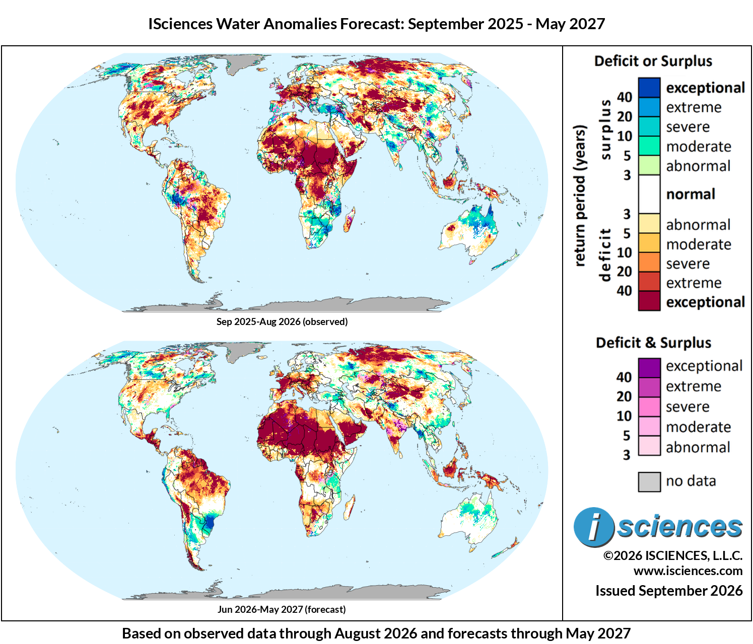
Figure 1: Worldwide water anomaly. Top: 12-month observed, Sep 2025–Aug 2026. Bottom: 12-month forecast, Jun 2026–May 2027.
The in focus and regional synopsis sections that follow provide highlights of regional water forecasts. Detailed regional maps are available in the full report: ISciences Global Water Monitor & Forecast Watch List September 14, 2026 (pdf).
In Focus
El Niño Strengthens Toward Historic Levels
For the first time in its 50-year history, the World Meteorological Organization has issued a near-certain forecast for a very strong El Niño, placing the probability of the event persisting through February 2027 at nearly 100%. Sea surface temperatures in the Niño 3.4 region have already reached +2.2°C to +2.6°C above the climatological average, with subsurface anomalies exceeding +8°C in some areas. The current event is expected to continue to intensify to historic levels through 2026, however, the September CFSv2 ensemble mean has moderated slightly from August’s peak projection.
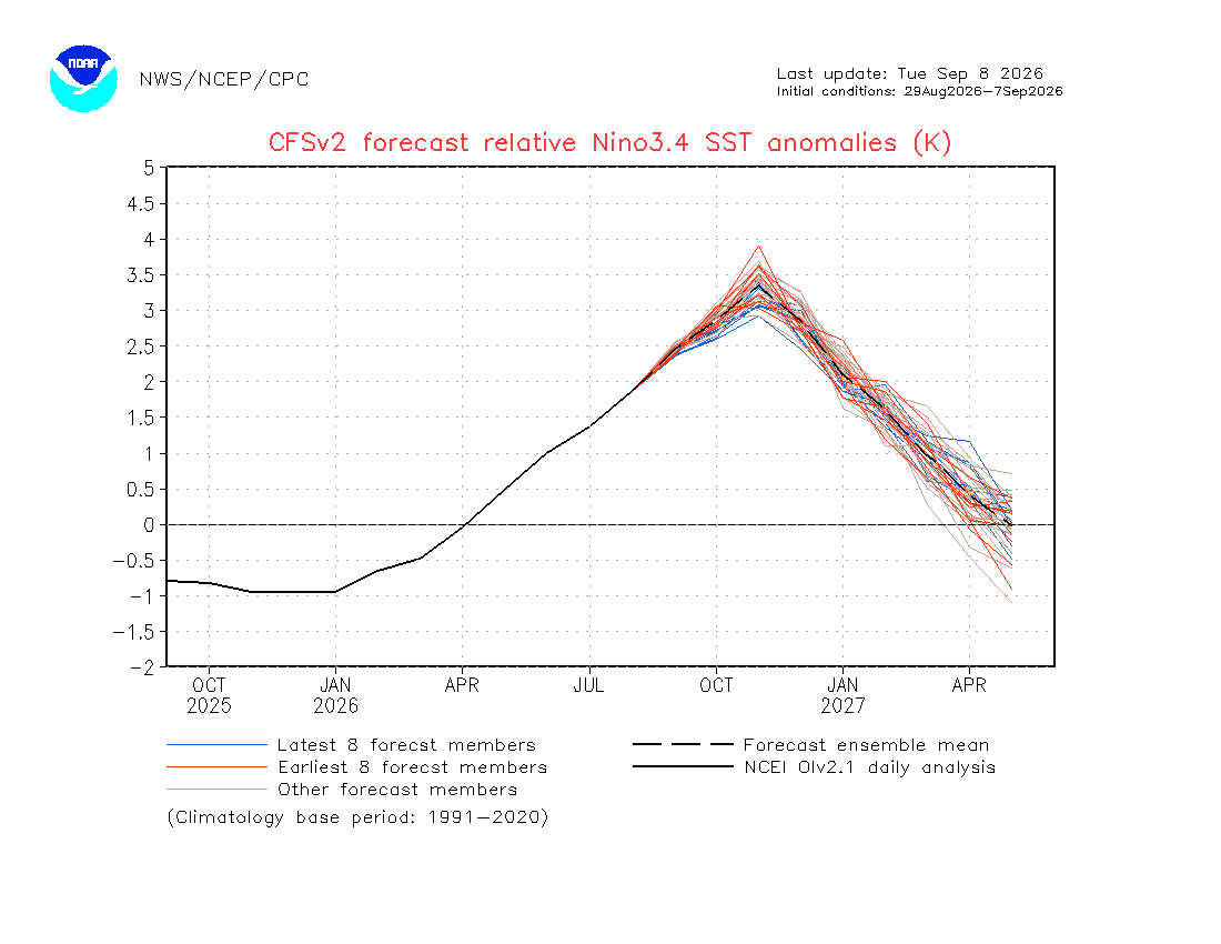
Figure 2: CFSv2 Relative Niño 3.4 SST anomaly ensemble forecast (E3, normalized monthly). The ensemble mean and spread of individual members show the trajectory of the 2026–2027 El Niño event. Source: NOAA CPC CFSv2.
The Colorado River Basin at a Breaking Point
Colorado has emerged as the epicenter of the current US drought. The National Integrated Drought Information System’s Intermountain West Drought Early Warning System estimates that nearly 91% of the state is under some level of drought classification, with approximately 14% in exceptional drought (D4), the largest percentage of any US state. Expanding to the five-state Intermountain West region, nearly 95% of Arizona, Colorado, New Mexico, Utah, and Wyoming are experiencing drought conditions, with roughly 30% classified as extreme or exceptional. State climatologist Allie Mazurek stated, “Colorado certainly stands out as one of the places experiencing some of the worst drought in the country.”
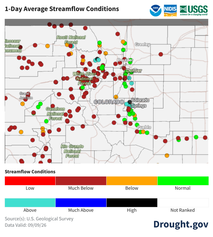
Figure 3: 1-day average streamflow conditions across Colorado, September 9, 2026. Nearly all gauges statewide register much below normal to low flows, with the Gunnison and upper Colorado River systems among the most severely stressed. Source: NOAA NIDIS/USGS, Drought.gov.
Europe and Central America Face Agricultural Concerns
As we continue to track the developing situation across Europe, the effects of Europe’s exceptional drought are resulting in agricultural emergencies. Harvest totals emerging in September are down nearly 10%: total EU and UK grain production is forecast at 286.6 million tonnes, down 23.4 million from 2025. The EU maize crop alone is near a two-decade low; Hungary’s harvest is expected at just 2.5 million tonnes, less than one-third of its 2018–2019 output, while Romania’s projected 8 million tonnes represents a drop of more than 50%. France’s corn harvest is on track to be its smallest since 1980. The drought’s reach extends beyond farms: on the Danube, water levels fell 60 centimeters below long-term lows through August, halting freight shipping in Austria; on the Rhine, Maersk and Hapag-Lloyd imposed Low Water Surcharges as barge operators suspended standard rate obligations.
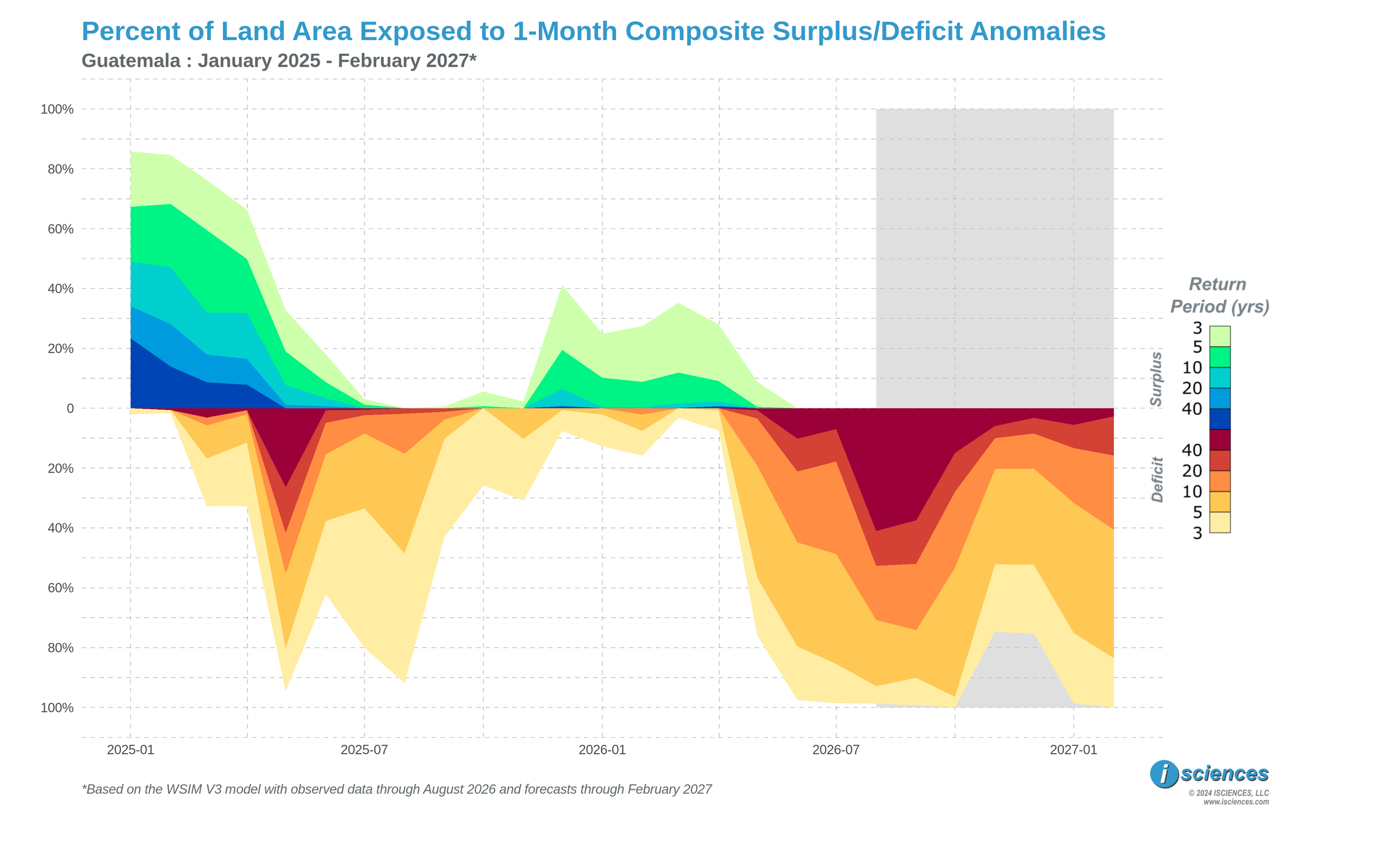

Figure 4: Percent of Guatemala’s land area exposed to 1-month composite water surplus (above zero) and deficit (below zero) anomalies, January 2025–February 2027. Shaded region indicates the forecast period. Source: ISciences WSIM V3.
In the Americas, catastrophic harvest failures have hit Central America’s Dry Corridor (a vulnerable arid strip spanning Guatemala, Honduras, El Salvador, and Nicaragua). A joint survey by Oxfam and Action Against Hunger across 91,000 rural households in 58 municipalities found that 78.6% of corn-growing families lost between 75%-100% of their production, and nearly two-thirds of bean-growing households suffered equivalent losses. Guatemala, home to the largest agricultural workforce in the Dry Corridor, bears the heaviest toll: El Niño has decimated an estimated 50% of the national corn harvest, and WSIM exposure analysis estimates that virtually all of the country’s land area is currently under water deficits, with roughly 40% currently under an “exceptional” deficit. Among households retaining any corn reserves at all, nearly two-thirds estimated their stocks would last three weeks or less. Honduras placed approximately 80% of national territory under drought alert, while El Salvador and Panama declared nationwide states of emergency on August 25. The World Food Programme’s regional director has warned that 16 million people across Latin America may face food insecurity as a result. As WSIM’s monthly forecasts have documented, the exceptional deficits across the Dry Corridor are projected to persist through the April 2027 forecast horizon, and the European Commission’s Joint Research Centre warned in early September that the October–December second planting season faces similar rainfall suppression, which may extend the food crisis well into 2027.
The disruption extends to the Panama Canal, where El Niño-related reservoir shortfalls prompted the authority to reduce daily Neopanamax transit slots beginning in September, with surcharges of $100 to $320 per container already in effect. Canal administrator Ilya Espino de Marotta has warned that quotas may need to be cut further in early 2027 depending on September–November rainfall, and some vessels have already paid more than $1 million at auction to secure transit slots. A permanent infrastructure solution at Rio Indio remains five to six years from completion. For the roughly 3% to 5% of global maritime trade that transits the canal, El Niño’s water footprint has become a logistics constraint with no near-term fix.
Watch List: Regional Synopsis
United States: Observed long-term conditions (Sep 2025–Aug 2026) show severe to exceptional deficits spanning nearly the entire region. The most intense deficits were observed across the Colorado River basin, southern Rockies through the Great Plains, the lower Mississippi Valley, the Mid-Atlantic coast, and northern New England. Alaska and southeast Florida contrast sharply with a mix of severe to exceptional surpluses. The seasonal forecasts (Jun 2026–May 2027) project widespread improvement across the country, with El Niño-driven precipitation expected to generate surpluses in western California, and the entire southern and eastern coasts stretching from Houston, TX to Boston, MA beginning Dec 2026 and expected to continue through early 2027.
Canada: Observed long-term conditions (Sep 2025–Aug 2026) show complex patterns of surpluses and deficits. A large area of mixed surplus-deficit conditions were observed in central-southern Alberta and transitioning to moderate to exceptional surpluses heading east towards Lake Winnipeg. Conversely, exceptional deficits covered Nova Scotia, while another band of extreme to exceptional deficits was present in the Northwest Territories, moving south into northern Alberta, east into north-central Saskatchewan, Manitoba, before dissipating in western Ontario. Northwestern British Columbia and the Yukon experienced water surplus. The seasonal forecasts (Jun 2026–May 2027) project gradual improvement across the Prairie provinces and British Columbia as El Niño-associated patterns shift, though moderate deficits are expected to persist in central Ontario while moderate to exceptional deficits are expected to intensify throughout Nunavut surrounding Hudson Bay.
Mexico, Central America, and the Caribbean: Observed long-term conditions (Sep 2025–Aug 2026) show moderate to exceptional deficits spanning northern Mexico from Sonora and Chihuahua through Coahuila, Nuevo León, and Tamaulipas, while exceptional deficits blanket the Central American Dry Corridor across western coastal Guatemala, Honduras, El Salvador, and Nicaragua, extending through Costa Rica and Panama; Cuba and Hispaniola register moderate to exceptional deficits along their western coasts. The seasonal forecasts (Jun 2026–May 2027) project some improvement across northern Mexico while El Niño intensifies exceptional deficits through the Dry Corridor into May 2027, with only southern Central America expected to see partial recovery.
South America: Observed long-term conditions (Sep 2025–Aug 2026) show extreme to exceptional deficits in most of the region except for surpluses in western Amazon Basin and the Andean slopes across Colombia, Ecuador, and Peru. The most intense deficits were concentrated in all of Venezuela, and in Brazil across northwestern Amazonas, Roraima, Mato Grosso, and Tocantins, and along the Paraná River watershed through Bolivia, Paraguay, and Argentina. The seasonal forecasts (Jun 2026–May 2027) show El Niño driving exceptional surpluses through May 2027 across central Argentina, extending into Uruguay and southern Brazil surrounding São Paulo, while northeastern Brazil and the broader Amazon basin retain moderate to extreme deficits through the forecast period.
Europe: Observed long-term conditions (Sep 2025–Aug 2026) show an exceptional deficit core stretching from the Portugal-France border east to the Poland-Bulgaria-Ukraine border region, north to southern United Kingdom and Sweden, and south across southern Italy, the central Balkan states and the Danube basin. Limited surpluses and mixed conditions were observed in the Iberian Peninsula, southern Balkans, and northernmost sections of Scandinavia. The seasonal forecasts (Jun 2026–May 2027) project the drought to persist, albeit reduced in intensity, through Nov 2026 before conditions are forecast to return to mostly normal conditions with pockets of severe deficits scattered through France, Germany, Czechia, and the Poland-Bulgaria-Ukraine border region beginning Dec 2026 and into 2027. Scandinavian surpluses are expected to expand south into Lithuania, Latvia, and Estonia.
Africa: Observed long-term conditions (Sep 2025–Aug 2026) show exceptional deficits covering most of the northern half of the continent from Mauritania to Sudan, along the Gulf of Guinea south to Angola, and east into the Democratic Republic of Congo. Exceptional deficits were also observed in the Horn of Africa, Madagascar, and the northern coast of Algeria. Moderate to severe surpluses blanketed large sections of Tanzania, Mozambique, Malawi, Eswatini, South Africa, Botswana, and southeast Angola. The seasonal forecasts (Jun 2026–May 2027) project northern deficits to reduce in intensity, but Sahel deficits to persist through the forecast horizon with minimal relief. Southeastern surpluses are expected to continue through Nov 2026 before receding to a core area surrounding Lake Victoria into 2027.
Middle East: Observed long-term conditions (Sep 2025–Aug 2026) show extreme to exceptional surpluses blanketing Turkey and the headwaters of the Euphrates and Tigris rivers, contrasting with severe to exceptional deficits in Yemen, and most of central and northern Iran. The seasonal forecasts (Jun 2026–May 2027) project surpluses throughout Turkey and the Euphrates and Tigris basin to gradually moderate in intensity and extent through May 2027. The southern Arabian Peninsula retains deficits through the forecast horizon.
Central Asia and Russia: Observed long-term conditions (Sep 2025–Aug 2026) show extreme to exceptional deficits dominating northern and central Russia and extending south through Kazakhstan as moderate to exceptional deficits, continuing across Uzbekistan, Turkmenistan, and the Amu Darya and Syr Darya watersheds before reaching Tajikistan and Kyrgyzstan. The seasonal forecasts (Jun 2026–May 2027) project Russia’s western and central deficits to persist largely unchanged while Kazakhstan sees patchy improvement. The southern republics of Tajikistan and Kyrgyzstan along with the Amu Darya and Syr Darya corridors are expected to transition to moderate to severe surpluses starting in Dec 2026 and continuing through May 2027.
South Asia: Observed long-term conditions (Sep 2025–Aug 2026) show severe to exceptional surpluses across central India through Maharashtra and Telangana. Moderate to exceptional surpluses were also observed across northern provinces of Rajasthan, Madhya Pradesh, Chhattisgarh, and transitioning to mixed surplus and deficit conditions along the eastern coast in Odisha. Exceptional deficits were present in northeast India and Bhutan, while less intense deficits were observed southern Indian states of Tamil Nadu and Kerala. The seasonal forecasts (Jun 2026–May 2027) indicate peninsular surpluses will transition to moderate deficits beginning Sep 2026 with widespread exceptional deficits emerging in Dec 2026 east of the Gulf of Khambhat in Gujarat and western Madhya Pradesh, before receding to the western coastline in Mar-May 2027.
Southeast Asia and the Pacific: Observed long-term conditions (Sep 2025–Aug 2026) show severe to exceptional deficits spanning the maritime archipelago from Sumatra and Java east through Borneo, Sulawesi, and Papua New Guinea, reflecting El Niño suppression of equatorial rainfall, while mainland Myanmar, Thailand, and the Mekong corridor have seen developing surpluses through the summer monsoon season. The seasonal forecasts (Jun 2026–May 2027) project exceptional deficits across the maritime regions to continue through Nov 2026, while mainland surpluses begin to expand and consolidate across Myanmar, Thailand, and Indochina by Dec 2026-Feb 2027 as El Niño conditions ease. Extreme to exceptional deficits are expected to re-emerge in Borneo, the Philippines, and New Guinea through 2027.
East Asia: Observed long-term conditions (Sep 2025–Aug 2026) show exceptional to extreme deficits dominating northern and western China from Xinjiang and Gansu through the central-western Yellow River basin and transitioning to moderate-severe surplus conditions moving towards Beijing. Surpluses surrounding Beijing extend in a long corridor south through Chongqing and further to the Yunnan and Nanning border region. Remaining moderate to severe deficits were observed south and west of Shanghai in the central plains, southern hills, northeast China and Manchuria, and the eastern coast of Japan. The seasonal forecasts (Jun 2026–May 2027) project northern deficits to persist, while deficits surrounding Shanghai are expected to transition to moderate to severe surpluses beginning Sep 2026 and extending through 2027. A large area of moderate to exceptional surpluses are expected to emerge across the Tibetan Plateau in early 2027 and continue through May 2027.
Australia & New Zealand: Observed long-term conditions (Sep 2025–Aug 2026) show moderate to exceptional surpluses covering northern Queensland, Northern Territory, south through the Lake Eyre basin, and most of New Zealand. Conversely, exceptional deficits covered a broad swath of inland and central Western Australia just east of Shark’s Bay, and throughout inland areas west of Sydney and Brisbane. The seasonal forecasts (Jun 2026–May 2027) project the northern Australian and New Zealand surpluses to gradually subside toward normal to moderate by late 2026, while inland deficits in the west and east are expected to return to normal conditions.